
Search Results
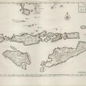
Kaart der Zuyd-Wester Eylanden van Banda
c.1724-1726
East Timor, Indonesia
Although this map’s title refers to the south-western islands of the Banda Islands, it actually focuses on the Lesser Sunda Islands, including Flores, Sumba and Timor. The islands feature mountains and jungle, with shoals and reefs around the coasts.

[Dutch portolan chart of the Lesser Sunda Islands]
c.1700
Indonesia, East Timor
Hand-drawn portolan (nautical) chart of the Lesser Sunda Islands, featuring a rhumbline network (the web of interconnected lines), shoals, reefs, elevations (side views of landmark mountains), and names of coastal settlements, all to aid navigation.


