Search

Search Results

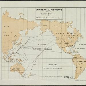
Commercial highways between United States and Asia and the islands of the Pacific

event1900

location_onBrunei, Cambodia, East Timor, Indonesia, Laos, Malaysia, Myanmar, Papua New Guinea, Philippines, Singapore, Southeast Asia, Thailand, Vietnam

The United States Treasury Department produced this map of trade routes crossing the Pacific Ocean between the United States and Asia. Each route is labelled with the names of its ports, and with the distance between them in miles.

Map of the Kingdom of Siam and its dependencies

eventc.1900

location_onMyanmar, Malaysia, Singapore, Thailand, Laos, Cambodia, Vietnam

The border of the Kingdom of Siam (Thailand) and its internal administrative districts are highlighted in yellow. Inset maps show the cities of Bangkok, Chiengmai (Chiang Mai) and Luang Pra Bang (Luang Prabang) in more detail.

China

event1898

location_onBrunei, Cambodia, East Timor, Indonesia, Laos, Malaysia, Myanmar, Philippines, Singapore, Southeast Asia, Thailand, Vietnam

This map highlights the colonisation of Southeast Asia, showing French Indochina (green), British Burma and Malaya (orange), the Dutch East Indies (pink), and the Spanish Philippines (green). In the region, only Siam (yellow) is independent.

Map of Siam and some of its tributary provinces

event1870

location_onCambodia, Laos, Myanmar, Thailand

A map of Siam (Thailand) and parts of Burma (Myanmar), Cambodia and Laos, focusing on the river networks, and the mountain ranges which are represented by hachures: short lines/dashes that give a sense of the shape and steepness of terrain.

[Manuscript map of Asia and Australia]

event1870

location_onSoutheast Asia, Singapore, Brunei, Cambodia, East Timor, Indonesia, Laos, Malaysia, Myanmar, Papua New Guinea, Philippines, Thailand, Vietnam

On this hand-drawn and coloured map of Asia, the colours differentiate the colonial territories of the European powers: for example, New Guinea is divided into Dutch, British and German areas, and Borneo is split between the British and Dutch.

A sketch of the rivers of Siam from the observations of the American missionaries

eventc.1860-1869

location_onThailand

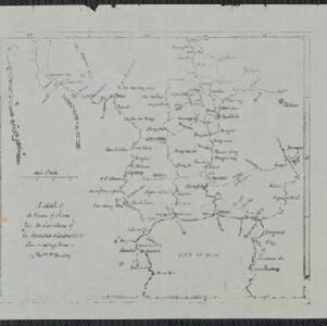
A sketch of the river networks discharging into the Gulf of Siam (Gulf of Thailand), derived from the observations of mid-19th century American missionaries. Settlements along the rivers are noted, as are areas where sugarcane was grown.

close

  • Filter from 1860 to 1900

Current results range from 1860 to 1900