Search

Search Results

Eastern Islands: Birmah &c.

event1846

location_onBrunei, Cambodia, East Timor, Indonesia, Laos, Malaysia, Myanmar, Philippines, Singapore, Southeast Asia, Thailand, Vietnam

On this map of Southeast Asia, British colonial territory is highlighted within red borders: the Straits Settlements (Singapore, Malacca and Penang) on the west coast of the Malay Peninsula; and British Burma (Chittagong and Aracan, and Tenasserim).

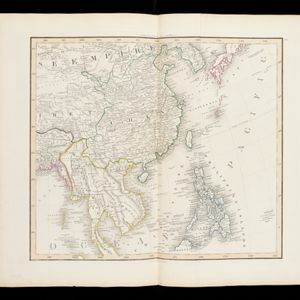
Asia. Plates 42-45 in Lizars' Edinburgh Geographical General Atlas

eventc.1844-1846

location_onBrunei, Cambodia, Indonesia, Laos, Malaysia, Myanmar, Philippines, Thailand, Vietnam

Southeast Asia is featured on the last of the four sheets of this map of Asia. The South China Sea is particularly detailed, with islands, rocks, shoals and reefs named, sometimes dated, and even marked with the name of the ship that mapped them.

East India Islands

event1839

location_onVietnam, Myanmar, Papua New Guinea, Philippines, Singapore, Southeast Asia, Thailand, Malaysia, Laos, Indonesia, East Timor, Cambodia, Brunei

The shoals and reefs of maritime Southeast Asia are highlighted on this colourful mid-19th century map, with the treacherous waters around many islands and straits marked.

Asia

eventc.1815-1817

location_onBrunei, Cambodia, East Timor, Indonesia, Laos, Malaysia, Myanmar, Papua New Guinea, Philippines, Singapore, Southeast Asia, Thailand, Vietnam

An early 19th century map, with the regions of Southeast Asia marked with different colours. Interestingly, Cambodia and modern Vietnam (labelled here as Cochinchina and Tonkin) are grouped with China.

The Eastern Hemisphere

event1801

location_onMyanmar, Brunei, Cambodia, East Timor, Indonesia, Laos, Malaysia, Vietnam, Thailand, Southeast Asia, Singapore, Philippines

Published by the English cartographer John Cary (c.1754–1835), this map is marked with the routes taken from Europe to Asia by the British Royal Navy captains James Cook, John Gore, and George Vancouver, as well as the French explorer Lapérouse.

Chart of East Indian Islands exhibiting the several Passages between the Indian and Pacific Oceans

event1800

location_onBrunei, Cambodia, East Timor, Indonesia, Laos, Malaysia, Myanmar, Philippines, Singapore, Southeast Asia, Thailand, Vietnam

Map focusing on the passages between the islands of maritime Southeast Asia. Many 18th century routes are labelled with the ship/captain’s name and date, and there are notes on some shoals and reefs recording names, details and incidents/shipwrecks.

East Indies

eventc.1800-1899

location_onBrunei, Cambodia, East Timor, Indonesia, Laos, Malaysia, Myanmar, Philippines, Singapore, Southeast Asia, Thailand, Vietnam

Longitude is indicated in two different ways on this mid-18th century map: along the top border, it is shown in degrees (number of degrees east of London); more unusually, along the bottom border, it is shown in time (number of hours east of London).

Asia, according to the best Authorities

event1795

location_onBrunei, Cambodia, East Timor, Indonesia, Laos, Malaysia, Myanmar, Philippines, Singapore, Southeast Asia, Thailand, Vietnam

A late 18th century map of Asia with regions divided by colour-coded borders, and detailing rivers, mountains, reefs and shoals.

Asia, according to the best Authorities

event1800

location_onBrunei, Cambodia, East Timor, Indonesia, Laos, Malaysia, Myanmar, Philippines, Singapore, Southeast Asia, Thailand, Vietnam

A late 18th century map of Asia with regions divided by colour-coded borders, and detailing rivers, mountains, reefs and shoals.

Bowles's new one-sheet map of Asia, divided into its empires, kingdoms, states, and other subdivisions

event1795

location_onBrunei, Cambodia, East Timor, Indonesia, Laos, Malaysia, Myanmar, Papua New Guinea, Philippines, Singapore, Southeast Asia, Thailand, Vietnam

A late 18th century map of Asia published in London by John Bowles, with regions indicated by colour. Central Borneo is labelled ‘Part inhabited by the Biayos’, which is seen on many contemporary maps, often with the comment ‘a savage people’.

The coast of India from Pulo Timon to Pulo Cambir comprehending the Malayan coast, the Gulf of Siam, the coasts of Tsiampa and Cochinchina, with the adjacent islands and part of the isle of Borneo

event1794

location_onThailand, Malaysia, Cambodia, Indonesia, Brunei, Vietnam

Nautical charts like this are detailed around the coasts and on the seas (e.g. river mouths, islands, shoals and reefs) while the interiors are blank. The web of lines is a rhumbline network, while the numbers indicate sea depth (bathymetry).

close