Search

Search Results

China

event1898

location_onBrunei, Cambodia, East Timor, Indonesia, Laos, Malaysia, Myanmar, Philippines, Singapore, Southeast Asia, Thailand, Vietnam

This map highlights the colonisation of Southeast Asia, showing French Indochina (green), British Burma and Malaya (orange), the Dutch East Indies (pink), and the Spanish Philippines (green). In the region, only Siam (yellow) is independent.

Zoological Geography: Sheet No. 3

event1849

location_onBrunei, Cambodia, East Timor, Indonesia, Laos, Malaysia, Myanmar, Papua New Guinea, Philippines, Singapore, Southeast Asia, Thailand, Vietnam

Two maps showing the distribution of rodent and ruminant animal species, including in Southeast Asia. Lines show the geographical range of individual species, alongside illustrations of the animals featured.

Mountain chains in Asia & Europe

event1849

location_onCambodia, Indonesia, Laos, Malaysia, Myanmar, Philippines, Singapore, Thailand, Vietnam

Mountain chains are represented by black lines; volcanoes by black dots. Three insets maps: expansion of Reguain—island of Taung-ywa, off the coast of Myanmar—due to volcanic activity; geology of Java (with heights of mountains); volcanoes of Luzon.

Asia, according to the best Authorities

event1795

location_onBrunei, Cambodia, East Timor, Indonesia, Laos, Malaysia, Myanmar, Philippines, Singapore, Southeast Asia, Thailand, Vietnam

A late 18th century map of Asia with regions divided by colour-coded borders, and detailing rivers, mountains, reefs and shoals.

Asia, according to the best Authorities

event1800

location_onBrunei, Cambodia, East Timor, Indonesia, Laos, Malaysia, Myanmar, Philippines, Singapore, Southeast Asia, Thailand, Vietnam

A late 18th century map of Asia with regions divided by colour-coded borders, and detailing rivers, mountains, reefs and shoals.

A new chart of the Oriental Seas and Islands... from the Isle of Ceylon to Amoye in China

event1790

location_onBrunei, Cambodia, East Timor, Indonesia, Laos, Malaysia, Myanmar, Philippines, Singapore, Southeast Asia, Thailand, Vietnam

A late 18th century maritime map of Southeast Asia, marked with expedition routes including the return of Captain Cook’s HMS Endeavour from Australia in 1770, and Captain Philip Carteret’s circumnavigation expedition in 1768.

Chart of the China Sea

event1746

location_onBrunei, Cambodia, Indonesia, Malaysia, Philippines, Vietnam

This map features eight expedition routes across the South China Sea from 1752 to 1763. The web of lines is a rhumbline network, and bathymetry (sea depth) is marked. The place names are in French, but with an English title and notes.

Deese wassende pas-kaart van Oost-Indien, is nu te bekoomen voor die deselve begeeren

eventc.1728-1738

location_onBrunei, Cambodia, East Timor, Indonesia, Laos, Malaysia, Myanmar, Papua New Guinea, Philippines, Singapore, Southeast Asia, Thailand, Vietnam

Map of the Indian Ocean dominated by a rhumbline network—a web of interconnected lines used to help plot routes—with a compass rose at the centre. At the top there are (incomplete) drawings of people with text in Dutch, French, English and Spanish.

Asia

event1705

location_onBrunei, Cambodia, East Timor, Indonesia, Laos, Malaysia, Myanmar, Philippines, Singapore, Southeast Asia, Thailand, Vietnam

Map of Asia from the second volume of ‘Navigantium atque itinerantium bibliotheca: or, A compleat collection of voyages and travels: consisting of above four hundred of the most authentick writers’ published by John Harris in 1705.

[Portolan chart of the South China Sea]

event1701

location_onBrunei, Cambodia, Indonesia, Laos, Malaysia, Philippines, Thailand, Vietnam

Hand-drawn portolan (nautical) chart, featuring a rhumbline network (the web of interconnected lines), bathymetry (sea depth), shoals and reefs, names of coastal settlements, and an elevation (side view) of a mountain at the north tip of Borneo.

Asia according to ye newest observations

eventc.1670-1732

location_onBrunei, Cambodia, East Timor, Indonesia, Laos, Malaysia, Myanmar, Papua New Guinea, Philippines, Singapore, Southeast Asia, Thailand, Vietnam

A map of Asia by the London-based cartographer Herman Moll (1654?–1732) with colour-coded regional borders. In Southeast Asia, each major land mass or island has its own coloured border.

Asia

eventc.1600-1699

location_onBrunei, Cambodia, East Timor, Indonesia, Laos, Malaysia, Myanmar, Philippines, Singapore, Southeast Asia, Thailand, Vietnam

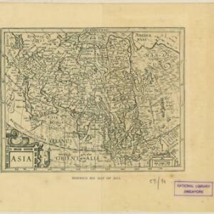
An early European map of Asia by the Flemish cartographer Hendrik Hondius (1573–c. 1650).

close