Search

Search Results

Stanford's Library Map of Asia

event1891

location_onBrunei, Cambodia, East Timor, Indonesia, Laos, Malaysia, Myanmar, Philippines, Singapore, Southeast Asia, Thailand, Vietnam

Southeast Asia is on sheet four of this map. British colonial territory—British Burma, the Straits Settlements, Sarawak, British North Borneo—is highlighted in red, with the Dutch East Indies, Spanish Philippines and Portuguese East Timor also shown.

Map of part of Moratau (Fergusson Island) and Duau (Normanby Island): British New Guinea

event1891

location_onPapua New Guinea

Map of parts of Fergusson and Normanby islands (east coast of New Guinea). Bathymetry (sea depth), reefs and shoals are marked, along with landmarks (mountains, villages, trees). Territories of two indigenous tribes—the Subia and Manayaya—are shown.

Rough Sketch of 200 miles of the western portion of British New Guinea, including rivers

event1890

location_onPapua New Guinea

Map of British New Guinea with notes on the terrain (‘Low country’), vegetation (‘Mangrove, Nipa and Fan Palms’), crops (‘Small plantations Sugar cane & Taro’), coastal features (‘Coral and Sand flats) and people (‘Friendly tribe’, ‘Dariamo Tribe’).

Map of the Fly River, British New Guinea, as traversed by Sir William MacGregor and party

event1890

location_onPapua New Guinea

Three maps on one sheet of the Fly River in British New Guinea, from the mouth to where it meets the Palmer River. Bathymetry (water depth) and sandbanks are marked at the mouth and landmarks—hills, vegetation, villages—are noted along the length.

Map of part of south-east New Guinea embracing its northern and southern waters

event1889

location_onPapua New Guinea

This map focuses on the southern coast including the capital Port Moresby, with the northern regions left mostly blank. There are four inset drawings of side views of mountains (elevations), and the border with German New Guinea is marked.

Sketch Map of Mai Cussa or Baxter River, and Wasu Cussa or Chester River, with their tributaries

event1888

location_onPapua New Guinea

Map of an expedition along two rivers on the southern coast of British New Guinea, with notes of terrain (‘Undulating country’), vegetation (‘Coconut Palms’) and wildlife (‘Flying Foxes’). More details have been added by hand (‘Ridge about 10ft.’).

Malay, or East Indian Archipelago, with Burmah, Siam &c.

event1887

location_onBrunei, Cambodia, East Timor, Indonesia, Laos, Malaysia, Myanmar, Philippines, Singapore, Southeast Asia, Thailand, Vietnam

On this map of Southeast Asia, numerous small islands, shoals and reefs are marked and named, especially in the South China Sea and around the Sunda and Maluku islands. Submarine cables to carry telegraph messages around the region are also shown.

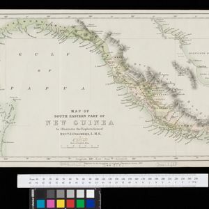
Map of South Eastern part of New Guinea: to illustrate the explorations of Rev. J. Chalmers, L.M.S.

event1887

location_onPapua New Guinea

Map of the southeast coast of British New Guinea, divided into administrative regions, with the northern regions left mostly blank. Based on the explorations of the Scottish missionary James Chalmers.

Singapore: Plan of harbour and roadstead

event1885

location_onSingapore

Plan of Singapore harbour, with wharfs and buildings. A roadstead—a body of water sheltered from tides/currents, for ships to anchor—is labelled ‘Singapore Road’. Islands, shoals and reefs are marked, as are roads and buildings in the city.

W. & A.K. Johnston's sheet of maps to illustrate the Caroline islands dispute between Germany and Spain

event1885

location_onSoutheast Asia, Papua New Guinea, Indonesia, Philippines, Malaysia, East Timor

Three maps of the Caroline Islands. One shows colonised areas in Southeast Asia: Dutch East Indies; British North Borneo, British New Guinea; German New Guinea; Philippines (Spain); Portuguese Timor. The route of the Challenger expedition is marked.

Sketch of Hué

event1885

location_onVietnam

Map of the city of Hué (Huế) on the Perfume River, east coast of Vietnam. There are forts, villages and rice fields along the river. In the city, there is the royal palace within walls and a moat, French military barracks and other colonial areas.

Map of the Malay Peninsula

event1883

location_onMalaysia, Singapore

The Straits Settlements are in red, with the rest of the map marked with names of local peoples (‘Inhabited by the Johor Jakuns’) and resources (mines). Many areas are left blank or vague as unexplored or approximate. Inset map of Singapore city.

close