
Search Results


Map of part of south-east New Guinea embracing its northern and southern waters
1889
Papua New Guinea
This map focuses on the southern coast including the capital Port Moresby, with the northern regions left mostly blank. There are four inset drawings of side views of mountains (elevations), and the border with German New Guinea is marked.

Sketch Map of Mai Cussa or Baxter River, and Wasu Cussa or Chester River, with their tributaries
1888
Papua New Guinea
Map of an expedition along two rivers on the southern coast of British New Guinea, with notes of terrain (‘Undulating country’), vegetation (‘Coconut Palms’) and wildlife (‘Flying Foxes’). More details have been added by hand (‘Ridge about 10ft.’).

Map of the Kingdom of Siam and its dependencies
1888
Cambodia, Laos, Malaysia, Myanmar, Thailand, Vietnam
Map of the Kingdom of Siam, featuring mountains, rivers and villages, and surrounded by a yellow border (the border with Upper Burma and China in the north is undefined). The southern part of Siam is shown on an inset map of the Malay Peninsula.

Malay, or East Indian Archipelago, with Burmah, Siam &c.
1887
Brunei, Cambodia, East Timor, Indonesia, Laos, Malaysia, Myanmar, Philippines, Singapore, Southeast Asia, Thailand, Vietnam
On this map of Southeast Asia, numerous small islands, shoals and reefs are marked and named, especially in the South China Sea and around the Sunda and Maluku islands. Submarine cables to carry telegraph messages around the region are also shown.


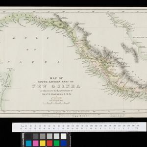
Map of South Eastern part of New Guinea: to illustrate the explorations of Rev. J. Chalmers, L.M.S.
1887
Papua New Guinea
Map of the southeast coast of British New Guinea, divided into administrative regions, with the northern regions left mostly blank. Based on the explorations of the Scottish missionary James Chalmers.

Plan of Port Moresby and the road to the Lolokie River: New Giunea
1887
Papua New Guinea
This map focuses on the capital city of British New Guinea, Port Moresby, and the road heading north-east from the city to the Laloki River. Along the road, there are descriptions of the terrain (‘Open flat fairly grasses timbered with bastard Gum’).

India, Burmah and the adjacent parts of Beluchistan, Afghanistan, Turkestan, the Chinese Empire, and Siam
1887
Myanmar, Thailand, Malaysia, Indonesia
British Burma is shown on the right of this two-sheet map of India. The green areas had come under British rule after the first and second Anglo-Burmese wars, with Upper Burma (light brown) being incorporated after the Third Anglo-Burmese War (1885).

Parts of Burma, Siam and the Shan States
1886
Myanmar, Thailand
This map charts the journey of Holt S. Hallett as he searched for a suitable route for a railway to transport British goods from Burma to Thailand and China. He wrote the book ‘A Thousand Miles on an Elephant in the Shan States’ about his expedition.

The external trade routes of India: with tables showing the amount and value of the principal exports and imports of the chief Indian sea ports and frontier states
1886
Myanmar, Thailand
This map of the trade routes of India includes Burma (Myanmar) and part of Siam (Thailand). The Rangoon and Irrawaddy Valley State Railway is marked. There are tables showing the values of imports and exports for each area, listed by produce type.
- Filter from 1598 to 1900
- Myanmar248
- Indonesia228
- Malaysia220
- Thailand213
- Singapore185
- Vietnam179
- Cambodia171
- Laos163
- Philippines156
- Brunei150
- East Timor132
- Southeast Asia130
- more Simple Location »


