Search

Search Results

L'Asie divisée en ses principales parties oú les Empires, Roïaumes, Etats et Peuples sont distingues les uns des autres

eventc.1740

location_onBrunei, Cambodia, East Timor, Indonesia, Laos, Malaysia, Myanmar, Philippines, Singapore, Southeast Asia, Thailand, Vietnam

The southern coast of Borneo is labelled ‘Cote des Mahometans [Coast of the Muslims]’. A note next to the Philippines states that they were discovered by Ferdinand Magellan in 1520 and are comprised of about 11,000 islands.

Nouvelle carte de l'Asie, avec des tables alphabetiques pour trouver sans peine les etats des principaux princes de cette partie du monde

event1732

location_onBrunei, Cambodia, East Timor, Indonesia, Laos, Malaysia, Myanmar, Philippines, Singapore, Southeast Asia, Thailand, Vietnam

Map showing the kingdoms, states and nations of Asia. They are listed—along with major cities and rivers—in an extensive key. Each location has a two letter code that identifies its location on the map (uppercase is longitude; lowercase is latitude).

L'Asie dressée sur les observations de Mrs. de l'Academie Royale de Sciences

event1730

location_onBrunei, Cambodia, East Timor, Indonesia, Laos, Malaysia, Myanmar, Philippines, Singapore, Southeast Asia, Thailand, Vietnam

This map features maritime routes: between Siam and Batavia; and five routes of the explorers Juan Gaetan and Olivier du Nord (dated 1542) east of the Philippines. The cartouche has a colourful illustration of Asian people in traditional costume.

Carte d'Asie: dressée sur les memoires envoyéz par le Czar a l'Academie Royale des Science

event1723

location_onBrunei, Cambodia, East Timor, Indonesia, Laos, Malaysia, Myanmar, Singapore, Philippines, Southeast Asia, Thailand, Vietnam

An early 18th century map of Asia by the French cartographer Guillaume Delisle (1675–1726). Regions are indicated with coloured borders, and the southern part of Borneo is labelled ‘Côte de Mahometans [Coast of the Muslims]’.

Carte d'Asie: dressée sur les memoires envoyéz par le Czar a l'Academie Royale des Science

eventc.1722-1774

location_onBrunei, Cambodia, East Timor, Indonesia, Laos, Malaysia, Myanmar, Philippines, Singapore, Southeast Asia, Thailand, Vietnam

An early 18th century map of Asia by the French cartographer Guillaume Delisle (1675–1726). Regions are indicated with coloured borders, and the southern part of Borneo is labelled ‘Côte de Mahometans [Coast of the Muslims]’.

Carte des Indes et de la Chine

eventc.1722-1774

location_onBrunei, Cambodia, East Timor, Indonesia, Laos, Malaysia, Myanmar, Philippines, Singapore, Southeast Asia, Thailand, Vietnam

This map uses coloured borders to show the ancient kingdoms of Southeast Asia. A label on the island of Borneo states ‘Beajous Idolatres habitans le milieu de l'Isle [Beajous idolaters inhabit the middle of the Island]’.

L'Asie distinguée suivant l'estendue de ses principales parties

event1720

location_onBrunei, Cambodia, East Timor, Indonesia, Laos, Malaysia, Myanmar, Philippines, Southeast Asia, Singapore, Thailand, Vietnam

This two-sheet map of Asia features a decorative cartouche with drawings of two women holding censers (incense burners), two cherubs, and a French coat of arms. On the map, mountains and forests are represented pictorially.

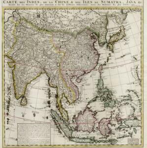
Carte des Indes, de la Chine & des Iles de Sumatra, Java &c.

event1719

location_onBrunei, Cambodia, East Timor, Indonesia, Laos, Malaysia, Myanmar, Philippines, Singapore, Southeast Asia, Thailand, Vietnam

Text on this map notes that Sumatra is divided into two equal parts by the Equator, so that the days and nights are always the same length. It also notes that Java is ruled by the Dutch, though the Mataram Sultanate in central Java is also mentioned.

L'Inde de la Le Gange

event1713

location_onBrunei, Cambodia, Indonesia, Laos, Malaysia, Myanmar, Thailand, Vietnam

This map of mainland Southeast Asia features a label describing the local population of the mountains of Cochinchine (Vietnam) as ‘les Kemoi Sauvages [the Kemoi savages]’. The cartouche features a drawing of Asia with people, fields and palm trees.

L'Asie dresse sur les observations de l'Academie Royale des Sciences, et quelques autres, et sur les memoires les plus recens

event1708

location_onBrunei, Cambodia, East Timor, Indonesia, Laos, Malaysia, Myanmar, Philippines, Singapore, Southeast Asia, Thailand, Vietnam

This early 18th century map of Asia features a note stating that there are new features on this map not seen on previous maps, and that this is not a mistake. The cartouche features a column of Asian people riding on horses and camels.

close