Search

Search Results

Deese wassende pas-kaart van Oost-Indien, is nu te bekoomen voor die deselve begeeren

eventc.1728-1738

location_onBrunei, Cambodia, East Timor, Indonesia, Laos, Malaysia, Myanmar, Papua New Guinea, Philippines, Singapore, Southeast Asia, Thailand, Vietnam

Map of the Indian Ocean dominated by a rhumbline network—a web of interconnected lines used to help plot routes—with a compass rose at the centre. At the top there are (incomplete) drawings of people with text in Dutch, French, English and Spanish.

Tabula Indiæ Orientalis et regnorum adjacentium

event1724

location_onBrunei, Cambodia, East Timor, Indonesia, Laos, Malaysia, Myanmar, Philippines, Singapore, Southeast Asia, Thailand, Vietnam

Colourful map of the East Indies focusing on maritime navigation: there is a compass rose at the centre of a rhumbline network (a web of lines to help plot routes). Shoals, reefs and islands are also marked.

Exactissima Asiae delineatio, in praecipuas regiones, ceterasq partes divisa

event1705

location_onBrunei, Cambodia, East Timor, Indonesia, Laos, Myanmar, Malaysia, Philippines, Singapore, Southeast Asia, Thailand, Vietnam

The illustration on this map highlights the wealth of the Asian trade routes, with merchants wearing colourful and elaborate robes presenting valuable treasures to a royal figure. A monkey, tortoise and camel emphasise the 'exoticism' of Asia.

Exactissima Asiae delineatio, in praecipuas regiones, ceterasq partes divisa

event1702

location_onBrunei, Cambodia, East Timor, Indonesia, Laos, Malaysia, Myanmar, Philippines, Singapore, Southeast Asia, Thailand, Vietnam

The illustration on this map highlights the wealth of the Asian trade routes, with merchants wearing colourful and elaborate robes presenting valuable treasures to a royal figure. A monkey, tortoise and camel emphasise the 'exoticism' of Asia.

[Chart of the Indian Ocean]

event1682

location_onCambodia, Indonesia, Malaysia, Myanmar, Singapore, Thailand

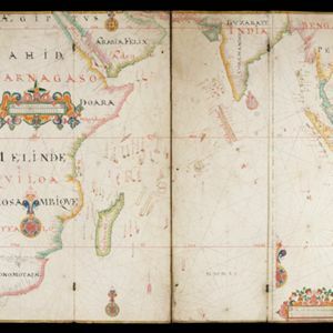
Colourful hand-drawn portolan (nautical) navigation chart, featuring a rhumbline network (the web of interconnected lines), islands, shoals and reefs. With elaborately decorated scales and compass roses. Mounted on folding wood boards.

close