Search

Search Results

Physical chart of the Indian Ocean: shewing the temperature of the water, the currents of the air and ocean, directions of the wind, districts of hurricanes, regions of the monsoons & ty-foons, trade routes &c&c.

event1849

location_onBrunei, Cambodia, East Timor, Indonesia, Laos, Malaysia, Myanmar, Papua New Guinea, Philippines, Singapore, Southeast Asia, Thailand, Vietnam

Chart of the Indian Ocean, showing climate and weather-related data, including around the seas and straits of Southeast Asia where trade routes are marked, along with monsoon and typhoon regions, and currents during the different monsoon seasons.

A chart of the Indian and Pacific Oceans with particular plans of the harbours

event1847

location_onBrunei, Cambodia, East Timor, Indonesia, Laos, Malaysia, Myanmar, Papua New Guinea, Philippines, Southeast Asia, Singapore, Thailand, Vietnam

Southeast Asia is shown on sheets two and three of this 12-sheet map of the Indian and Pacific oceans, including detailed inset maps of the straits of Singapore, Bangka, Gaspar and Sunda, with bathymetry (sea depth), shoals, reefs, anchorages etc.

Algemeene kaart van de ontdekkingen van kapit. J. Cook gedaan op zyne drie togten met de koers van de schepen onder zyn bevel

event1795

location_onBrunei, Cambodia, East Timor, Indonesia, Laos, Malaysia, Myanmar, Papua New Guinea, Philippines, Singapore, Southeast Asia, Thailand, Vietnam

Map charting the three expeditions of the British Royal Navy captain James Cook, including HMS Endeavour’s journey via Batavia (Jakarta) in 1770, and HMS Resolution’s journey through the South China Sea (after Cook’s death) in 1779.

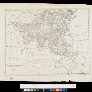
A New & Accurate Map of Asia

event1777

location_onBrunei, Cambodia, East Timor, Indonesia, Laos, Malaysia, Myanmar, Papua New Guinea, Philippines, Singapore, Southeast Asia, Thailand, Vietnam

Created for Middleton’s ‘Complete System of Geography’, this map of Asia includes the ancient kingdoms of mainland Southeast Asia, the Sunda Islands and Moluccas of maritime Southeast Asia, as well as the Philippines and New Guinea.

Deese wassende pas-kaart van Oost-Indien, is nu te bekoomen voor die deselve begeeren

eventc.1728-1738

location_onBrunei, Cambodia, East Timor, Indonesia, Laos, Malaysia, Myanmar, Papua New Guinea, Philippines, Singapore, Southeast Asia, Thailand, Vietnam

Map of the Indian Ocean dominated by a rhumbline network—a web of interconnected lines used to help plot routes—with a compass rose at the centre. At the top there are (incomplete) drawings of people with text in Dutch, French, English and Spanish.

close