Search

Search Results

Kaart van de Kleine Soenda eilanden

event1898

location_onIndonesia

The Lesser Sunda Islands are shown spread over these three late 19th century maps. Each island is divided into local administrative districts, with cities, mountains and routes marked. Shoals, lighthouses and anchor points are shown at the coasts.

Expeditiën naar Bali in 1846, -48, -49 en -68

event1897

location_onIndonesia

Map of Bali, with five inset maps showing locations of Dutch military interventions on the island from 1846 to 1868. Troop positions and Balinese defences—barricades, moats—are marked, along with terrain, roads, palaces, temples and villages.

Kaart van het Eiland Bali

event1897

location_onIndonesia

Bali under Dutch colonial rule is shown here divided into eight regencies (administrative divisions). Contour lines indicate elevation, with the heights of some mountains noted. Shoals, reefs and sandbanks are marked around the coast.

Schets-taalkaart van de Kleine Soenda eilanden

event1893

location_onIndonesia

This map is colour-coded to show the different languages and dialects spoken in the Lesser Sunda Islands in the late 19th century.

Plannen van ankerplaatsen Kleine Soenda eilanden

event1893

location_onIndonesia

Fifty-seven separate maps of bays, roadsteads—a body of water sheltered from tides/currents—and anchor points around the Lesser Sunda Islands. Landmarks, lighthouses, bathymetry (sea depth), shoals, reefs and other obstructions are marked.

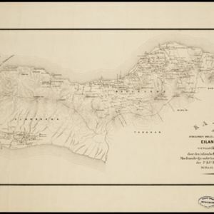
Kaart der afdeelingen Boelèlèng en Djambrana, eiland Bali, vervaardigd in 1885

event1886

location_onIndonesia

Contour lines show the terrain of these two districts at the western end of the island of Bali. Roads connecting the ‘desa’s [villages]’, Hindu temples and rivers are marked. Anchor points around the coast are marked for ships or for local vessels.

Het eiland Java benevens Bali

event1861

location_onIndonesia

This map shows Java and Bali divided into Dutch colonial administrative areas (‘residencies’), and features mountains, rivers, settlements, and routes. It was designed to be folded within book covers so it could be easily carried.

Het eiland Java benevens Bali

event1861

location_onIndonesia

This map shows Java and Bali divided into Dutch colonial administrative areas (‘residencies’), and features mountains, rivers, settlements, and routes. It was designed to be folded within book covers so it could be easily carried.

Kaart van het eiland Java

event1845

location_onIndonesia

This map of Java uses hachures: short lines/dashes that give a sense of the shape and steepness of terrain. The coast is marked with shoals and reefs (dotted lines and crosses), bathymetry (sea depth, in figures) and anchor points (anchor symbols).

Reduzirte Karte vom Sunda- oder Borneo-Meere

event1835

location_onMalaysia, Indonesia

A navigation map of the Java Sea and Sunda Islands, with bathymetry (sea depth), maritime routes, shoals and reefs, and elevations (side views of terrestrial landmarks). Inset maps feature the bay at Batavia and the straits between the Sunda Islands.

Kaart van het eiland Groot Java

event1798

location_onIndonesia

Map of Java divided into administrative areas. Mountains are shown pictorially, major rivers are named, and the coasts have shoals. The map is orientated with south at the top, so the island looks ‘upside down’ compared to how it is usually shown.

close

  • Filter from 1700 to 1898

Current results range from 1700 to 1898