Search

Search Results

Vaarwaters en ankerplaatsen nabij het eiland Banka

event1898

location_onIndonesia

Four navigation maps of locations around Banka (Bangka) Island, east of Sumatra. Anchor points, lighthouses, bathymetry (sea depth), shoals and other obstructions and landmarks (hills, buildings, trees) are shown.

Straat Banka: Zuidblad

event1897

location_onIndonesia

Navigation map of the southern part of the Bangka Strait between Sumatra and Bangka Island. Bathymetry (sea depth), lighthouses, reefs, shoals and other obstructions (clay, coral, mud, stones, sand) are marked.

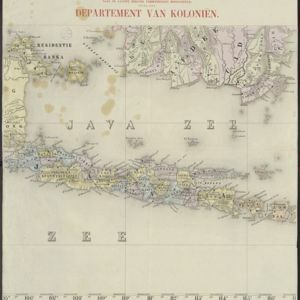
Atlas van Nederlandsch Oost-Indië

eventc.1897-1904

location_onIndonesia

Very detailed atlas of the entire Dutch East Indies, over 16 map sheets, with a cover and overview map. Includes topographic maps, inset maps of cities and islands, and maps featuring land and sea routes, languages, geology, colonial territory etc.

Kaart van de residentie Banka

event1896

location_onIndonesia

Map of the island and residency of Bangka, divided into districts and sub-districts, and featuring mountains, rivers, wetlands, and settlements. The surrounding seas are marked with buoys, depth lines, anchor points, shoals and reefs.

Sumatra, Bangka, Blitoeng en de Riouw-archipel

event1890

location_onIndonesia

This map of Sumatra is divided into administrative areas called ‘residencies’, which include the surrounding islands such as the Riau Archipelago and islands in the South China Sea.

Schets-taalkaart van de residentie Bangka / Schets-taalkaart van den Riouw- en Lingga-archipel

event1889

location_onIndonesia

Two separate maps showing the languages and dialects spoken on the islands of Bangka, and the Riouw (Riau) and Lingga archipelagos, in the late 19th century. On Bangka alone, there are 12 languages or dialects listed.

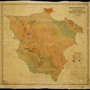
Geognostisch-mijnbouwkundige kaart van het eiland Bangka, distrikt Blinjoe

event1872

location_onIndonesia

A geological map showing the types of rock and minerals found in Blinjoe district on the island of Bangka, off the east coast of Sumatra. Deposits of iron, quartz and tin are marked, and coral is shown at the coast.

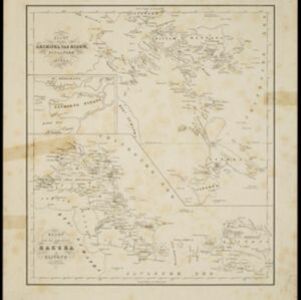
Kaart van den archipel van Riouw, Singapore en Lingga / Kaart van de eilanden Bangka en Blitong

event1857

location_onIndonesia, Singapore

Two maps featuring many of the islands between the Malay Peninsula, Sumatra and Borneo. In the top map, Batam, Bintan, Lingga and many of the smaller Riau Islands. In the bottom map, Bangka and Belitung on the east coast of Sumatra.

School-kaart van Oost-Indië

event1854

location_onIndonesia

One sheet (of eight) from a map of the Dutch East Indies, used in schools in the mid-19th century. Java is divided into residencies, and mountains—represented by short lines/dashes called hachures—major roads and settlements are shown.

Java 1848

event1848

location_onIndonesia

Map of Java divided into three provinces: West Java, Central Java and East Java. Major settlements and islands are named. Mountains are represented by hachures, short lines/dashes that give a sense of the shape and steepness of terrain.

Java 1848

event1848

location_onIndonesia

Map of Java divided into three provinces: West Java, Central Java and East Java. Major settlements and islands are named. Mountains are represented by hachures, short lines/dashes that give a sense of the shape and steepness of terrain.

Reduzirte Karte vom Sunda- oder Borneo-Meere

event1835

location_onMalaysia, Indonesia

A navigation map of the Java Sea and Sunda Islands, with bathymetry (sea depth), maritime routes, shoals and reefs, and elevations (side views of terrestrial landmarks). Inset maps feature the bay at Batavia and the straits between the Sunda Islands.

close

  • Filter from 1700 to 1898

Current results range from 1700 to 1898