
Search Results
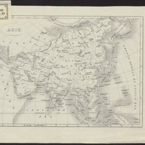

Azië : 1861
1861
Brunei, Cambodia, East Timor, Indonesia, Laos, Malaysia, Myanmar, Papua New Guinea, Philippines, Singapore, Southeast Asia, Thailand, Vietnam
Map of Asia published by the North Holland Regional Association of the Dutch Teachers' Association. Mainland Southeast Asia is labelled ‘Achter Indie [Beyond India]’; the Indonesian Archipelago is labelled ‘Indische Archipel [Indian Archipelago]’.

Asien
c.1850
Brunei, Cambodia, East Timor, Indonesia, Laos, Malaysia, Myanmar, Papua New Guinea, Philippines, Singapore, Southeast Asia, Thailand, Vietnam
On this map of Asia, colours are used to show the colonial territories of the European powers, and to show Muslim and Buddhist regions: Sumatra is divided between the Netherlands and local rulers; the Straits Settlements underlined in red (British).

Zoological Geography: Sheet No. 3
1849
Brunei, Cambodia, East Timor, Indonesia, Laos, Malaysia, Myanmar, Papua New Guinea, Philippines, Singapore, Southeast Asia, Thailand, Vietnam
Two maps showing the distribution of rodent and ruminant animal species, including in Southeast Asia. Lines show the geographical range of individual species, alongside illustrations of the animals featured.
Asia
1826
Brunei, East Timor, Cambodia, Indonesia, Laos, Malaysia, Myanmar, Papua New Guinea, Philippines, Singapore, Southeast Asia, Thailand, Vietnam
This map of Asia is from the earliest version of ‘Stielers Handatlas’ by the German cartographers Adolf Stieler and Christian Gottlieb Reichard. The maps were initially published separately; later editions compiled them into book form.
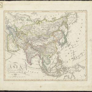


