Search

Search Results

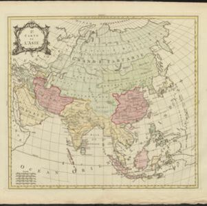
2e. carte de l'Asie

event1755

location_onBrunei, Cambodia, East Timor, Indonesia, Laos, Malaysia, Myanmar, Philippines, Singapore, Southeast Asia, Thailand, Vietnam

Mid-18th century French-language map of Asia, with Southeast Asia divided into four regions: the mainland in yellow, the Philippines in green, the Sunda Islands in red, and the Maluku Islands in yellow.

Suite du plan contenant depuis Camboya, Cochinchine jusques à Canton avec les Isles Aimant et Philipines

eventc.1750

location_onCambodia, Philippines, Vietnam

Map of the South China Sea between mainland Southeast Asia and the Philippines. Shoals and reefs, especially the Paracel Islands (‘Poulo Parcellas’), are shown. Bathymetry (sea depth) is indicated by the numbers marked along coastal routes.

Asia: ex magna orbis terre descriptione Gerardi Mercatoris desumpta, studio & industria G.M. Iunioris

event1630

location_onBrunei, Cambodia, East Timor, Indonesia, Laos, Malaysia, Myanmar, Philippines, Singapore, Southeast Asia, Thailand, Vietnam

Originally published in Gerardus Mercator's ‘Atlas Sive Cosmographicae Meditationes de Fabrica Mundi et Fabricati Figura’ (1595), the title of which was the first use of the word ‘atlas’ to refer to a collection of maps. This is a 1630 reprint.

close

  • Filter from 1630 to 1755

Current results range from 1630 to 1755