Search

Search Results

Bataviasche havenwerken

event1880

location_onIndonesia

A map of the rail, canal and road connections of Batavia (Jakarta, Java) and its port of Tanjung Priok. There is an inset map of the port—harbours, dock, coal sheds, well and water tower—and cross-sections of the inner harbour walls and harbour dam.

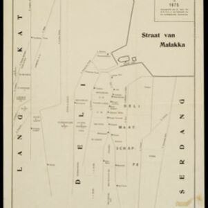
Schetskaart van de Deli-ondernemingen in 1875

event1880

location_onIndonesia

Map of Deli on the northeast coast of Sumatra, divided into parcels of land which are labelled—in capital letters—with the names of businesses. Place names are in lowercase. The coast, rivers and land parcels are rendered in simple straight lines.

Kaart van het eiland Sumatra

event1880

location_onMalaysia, Indonesia, Singapore

The use of hachures—short lines/dashes that give a sense of the shape and steepness of terrain—highlight the mountain ranges along the west coast of this map of Sumatra. Many rivers flow east from the mountains to the Malacca Strait.

Fort Nieuw Victoria

event1880

location_onIndonesia

Two plans of Fort New Victoria in Ambon, Maluku Islands. There is a pier at the front of the fort which projects into Ambon Bay. In the second plan, the fort has seven bastions and a moat at the rear.

[Schetskaarten van versterkingen, loopgraven, stellingen, bentengs e.d. uit de Atjeh oorlog]

event1880

location_onIndonesia

Multiple maps from the Aceh War, spread over 12 sheets. Includes maps of fortifications, trenches, battle formations; building plans, including the Aceh Sultan’s palace; topographic maps; and drawings of a ‘kotta mara’ (fortified raft).

close