
Search Results


Kaart van de Westerhelft der Residentie Timor
1860
Indonesia
Map of the western half of the Dutch colonial administrative region (residency) of Timor, featuring Flores, Komodo, Sumba and Savu islands, and their straits. (From ‘Algemeene Atlas van Nederlandsche Indie [General Atlas of the Dutch East Indies]’.)

Kaart van de Oosterhelft der Residentie Timor
1860
Indonesia
Map of the eastern half of the Dutch colonial administrative region (residency) of Timor, with an inset map of its capital city and port Timorkoepang (Kupang). (From ‘Algemeene Atlas van Nederlandsche Indie [General Atlas of the Dutch East Indies]’.)

A new chart of the eastern straits to China drawn from the best authorities
1800
Indonesia
Two maps of routes around the Flores and Banda seas—through the straits between the Lesser Sunda Islands and the Maluku Islands—towards China. Includes a rhumbline network—a web of lines to help plot routes—bathymetry (sea depth), shoals and reefs.

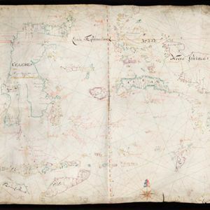
[Dutch portolan chart of the eastern Dutch East Indies]
1700
Indonesia, East Timor
This colourful hand-drawn portolan (nautical) chart was designed to aid navigation. It features a rhumbline network (the web of interconnected lines), bathymetry (sea depth), shoals and reefs, anchor points and written notes.

[Dutch portolan chart of the Lesser Sunda Islands]
c.1700
Indonesia, East Timor
Hand-drawn portolan (nautical) chart of the Lesser Sunda Islands, featuring a rhumbline network (the web of interconnected lines), shoals, reefs, elevations (side views of landmark mountains), and names of coastal settlements, all to aid navigation.


