Search

Search Results

Map of the Burman Empire including also Siam, Cochin-China, Ton-king and Malaya

event1842

location_onVietnam, Myanmar, Malaysia, Indonesia, Thailand, Laos, Cambodia, Brunei, Singapore

Regional borders are colour-coded on this mid-19th century map of mainland Southeast Asia, with British colonial territory in red (including part of the Burman Empire, the Straits Settlements, and Sarawak on Borneo).

Map of the Burman Empire including also Siam, Cochin-China, Ton-king and Malaya

eventc.1840-1852

location_onVietnam, Malaysia, Myanmar, Cambodia, Thailand, Laos, Singapore, Brunei

Although this mid-19th century map covers all of mainland Southeast Asia, the Burman Empire (Myanmar) is shown in greater detail, especially its districts, rivers and place names. It was produced by the James Wyld, geographer to Queen Victoria.

East India Islands

event1839

location_onVietnam, Myanmar, Papua New Guinea, Philippines, Singapore, Southeast Asia, Thailand, Malaysia, Laos, Indonesia, East Timor, Cambodia, Brunei

The shoals and reefs of maritime Southeast Asia are highlighted on this colourful mid-19th century map, with the treacherous waters around many islands and straits marked.

East Indies

eventc.1800-1899

location_onBrunei, Cambodia, East Timor, Indonesia, Laos, Malaysia, Myanmar, Philippines, Singapore, Southeast Asia, Thailand, Vietnam

Longitude is indicated in two different ways on this mid-18th century map: along the top border, it is shown in degrees (number of degrees east of London); more unusually, along the bottom border, it is shown in time (number of hours east of London).

Les Isles de la Sonde, Moluques, Philippines, Carolines, et Mariannes

event1795

location_onBrunei, Cambodia, East Timor, Indonesia, Laos, Malaysia, Myanmar, Philippines, Singapore, Southeast Asia, Thailand, Vietnam

This map of the Sunda Isles (‘Isles de la Sonde’) (with red borders) and Maluku Islands (‘Isles Moluques’) (green borders) also includes mainland Southeast Asia (blue borders), the Philippines (yellow borders) and New Guinea (green borders).

The East India Islands: comprehending the Isles of Sunda, the Moluccas and the Philippine Islands

event1789

location_onBrunei, Cambodia, East Timor, Indonesia, Laos, Malaysia, Myanmar, Philippines, Singapore, Southeast Asia, Thailand, Vietnam

Labels on this late 18th century map of Southeast Asia describe two indigenous populations—the ‘Kemoy’ of the mountains along the border of Cochin China (Vietnam) and Camboja (Cambodia), and the ‘Biayos’ of central Borneo—as ‘a wild Nation’.

La Presqu'isle de l'Inde au delà du Gange, avec l'Archipel des Indes. Partie occidentale

event1785

location_onBrunei, Cambodia, Indonesia, Laos, Malaysia, Myanmar, Singapore, Thailand, Vietnam

In the 18th century, European maps tended to use their own country’s meridian, so on this French map of Southeast Asia longitude is measured from the Paris Meridian. Eleven different scales are also shown.

Present Asia

event1783

location_onVietnam, Myanmar, Philippines, Singapore, Southeast Asia, Thailand, Malaysia, Laos, Indonesia, East Timor, Cambodia, Brunei

Coloured borders divide this late 18th century map of Asia into empires, kingdoms and regions. Five major rivers that flow south through mainland Southeast Asia are named: Aua, Pegu, Tenasserim, Menan and Camboya.

Les Isles de la Sonde, Moluques, Philippines, Carolines, et Mariannes

event1778

location_onBrunei, Cambodia, East Timor, Indonesia, Laos, Malaysia, Myanmar, Philippines, Singapore, Southeast Asia, Thailand, Vietnam

This map of the Sunda Isles (‘Isles de la Sonde’) (with red borders) and Maluku Islands (‘Isles Moluques’) (blue borders) also includes mainland Southeast Asia (green borders), the Philippines (yellow borders) and New Guinea (green borders).

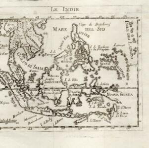
Le Indie

event1778

location_onBrunei, Cambodia, East Timor, Indonesia, Laos, Malaysia, Myanmar, Philippines, Singapore, Southeast Asia, Thailand, Vietnam

This late 18th century map of Southeast Asia is by the Dutch cartographer Henri Abraham Chatelain (1648–1743). As often found on maps of this time, larger settlements are represented by drawings of small groups of buildings.

Carte des Isles de Java, Sumatra, Borneo &a. Les detroits de la Sunde, Malaca, et Banca, Golfe de Siam &a.

eventc.1772-1780

location_onBrunei, Cambodia, Indonesia, Malaysia, Philippines, Singapore, Thailand, Vietnam

This map shows the islands of Java, Sumatra and Borneo, the straits of Sunda, Malacca and Bangka, and the Gulf of Siam. The title is given in both French and Dutch, as are some of the place names on the map.

Carte hydro-geo-graphique des Indes orientales, en deca̧ et au dela du Gange avec leur archipel

event1771

location_onBrunei, Cambodia, East Timor, Indonesia, Laos, Malaysia, Myanmar, Philippines, Singapore, Southeast Asia, Thailand, Vietnam

The arrows on this map show the direction of the seasonal monsoons of Southeast Asia during the late 18th century. Each arrow has a label in French, indicating the month. The hatched sea areas are where the winds always blow in the same direction.

close

  • Filter from 1650 to 1842

Current results range from 1650 to 1842