Search

Search Results

East Indies

eventc.1800-1899

location_onBrunei, Cambodia, East Timor, Indonesia, Laos, Malaysia, Myanmar, Philippines, Singapore, Southeast Asia, Thailand, Vietnam

Longitude is indicated in two different ways on this mid-18th century map: along the top border, it is shown in degrees (number of degrees east of London); more unusually, along the bottom border, it is shown in time (number of hours east of London).

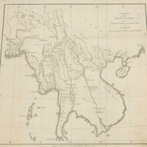
A sketch of the Birman Empire: from a Map of India extra Ganjem

event1800

location_onCambodia, Laos, Myanmar, Thailand, Vietnam

This map from 1800 is by the Scottish cartographer Alexander Dalrymple, who was the first Hydrographer of the British Admiralty. It documents the river systems of the Birman Empire (Myanmar) and modern Thailand, Laos, Cambodia and Vietnam.

East Indies

event1769

location_onBrunei, Cambodia, East Timor, Indonesia, Laos, Malaysia, Myanmar, Philippines, Singapore, Southeast Asia, Thailand, Vietnam

Longitude is indicated in two different ways on this mid-18th century map: along the top border, it is shown in degrees (number of degrees east of London); more unusually, along the bottom border, it is shown in time (number of hours east of London).

Carte de l'Inde au-delà du Gange comprenant les Royaumes de Siam, de Tunquin, Pegu, Ava, Aracan &c.

event1750

location_onMalaysia, Cambodia, Myanmar, Thailand, Vietnam, Laos

A mid-18th century map showing mainland Southeast Asia divided into regions such as Pegu, Ava and Aracan (Myanmar), Siam (Thailand), Laos, Camboie (Cambodia), Cochinchine and Tunquin (Vietnam), and Malaca (Malaysia).

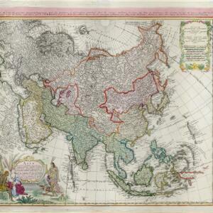
Asia secundum legitimas projectionis stereographicae regulas et juxta recentissimas observation et relationes = Carte de l'Asie, projettée stereographiquement, tirée des relations et observations

event1744

location_onBrunei, Cambodia, East Timor, Indonesia, Laos, Malaysia, Myanmar, Philippines, Singapore, Southeast Asia, Thailand, Vietnam

This mid-18th century map of Asia has a stereographic projection to aid in navigation. There is also an illustration featuring two Asian men depicted as warriors, with a robed woman, as well as a large lizard.

Asiæ pars Avstralis. Insulæ indicae cvm svis naturæ dotibvs

eventc.1702-1710

location_onBrunei, Cambodia, East Timor, Indonesia, Laos, Malaysia, Myanmar, Papua New Guinea, Philippines, Singapore, Southeast Asia, Thailand, Vietnam

This early 17th century map of Southeast Asia is beautifully decorated with images of wild animals, including camels, a rhinoceros and various birds and fish. There is also a large decorative compass rose.

Ancient Asia according to its general divisions and names of its countries together with their chief cities, rivers, mountains &c.

event1700

location_onBrunei, Cambodia, East Timor, Indonesia, Laos, Malaysia, Myanmar, Philippines, Singapore, Southeast Asia, Thailand, Vietnam

Interestingly, this map from the year 1700 shows the world as the Greeks and Romans knew it. Therefore, Southeast Asia is labelled as 'PARTS UNKNOWN TO THE ANCIENTS' and lacks place names e.g. Sumatra is named ‘Taprobana I. according to some’.

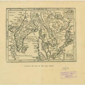
India orientalis

event1630

location_onBrunei, Cambodia, Indonesia, Laos, Malaysia, Myanmar, Philippines, Singapore, Southeast Asia, Thailand, Vietnam

Four long rivers flow south through mainland Southeast Asia on this map: the ‘Menan’, ‘Manthabam’ and ‘Cosmin’ originate at a mythical lake (‘Chiamai Lacus’) in southern China, while the ‘Mecon’ (Mekong) flows from the hills of Cochinchina (Vietnam).

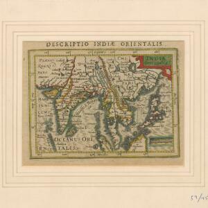
Descriptio Indiæ orientalis

event1607

location_onBrunei, Cambodia, Indonesia, Laos, Malaysia, Myanmar, Philippines, Singapore, Southeast Asia, Thailand, Vietnam

This early 17th century map features a number of mythical lakes that were once thought to exist in southern China. One of these lakes feeds three rivers—labelled ‘Menam’, ‘Manthabam’ and ‘Cosmin’—which flow south through mainland Southeast Asia.

India orientalis

eventc.1600-1699

location_onVietnam, Myanmar, Malaysia, Philippines, Singapore, Southeast Asia, Thailand, Laos, Indonesia, Cambodia, Brunei

This 17th century map features a number of mythical lakes once thought to exist in southern China. One of these lakes (‘Chiamai Lac’) feeds three rivers—labelled ‘Menan’, ‘Manthabam’ and ‘Cosmin’—which flow south through mainland Southeast Asia.

Tabvla Asiæ VIII

eventc.1596-1621

location_onMyanmar

Early map by Giovanni Antonio Magini, based on the work of the 2nd century geographer Ptolemy. It is difficult to pinpoint exact locations, but the area labelled ‘India Extra Ganges [India beyond the Ganges]’ could include some of modern Myanmar.

Tabvla Asiae VIII

eventc.1545-1552

location_onMyanmar

Early map by Sebastian Münster, based on the work of 2nd century geographer Ptolemy, featuring strange deformed monsters, including headless men with faces on their torsos, a man with a dog’s head, and a mythical race of cannibals (‘Anthropophagi’).

close

  • Filter from 1545 to 1800

Current results range from 1545 to 1800