
Search Results
43 Results found

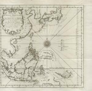
Suite de l'Ocean Oriental contenant les Isles de la Sonde, les costes de Tunquin et de la Chine, les isles du Japon, les Philippines, Moluques
1746
Brunei, Cambodia, East Timor, Indonesia, Malaysia, Papua New Guinea, Philippines, Singapore, Thailand, Vietnam, Southeast Asia
The coast of New Guinea (‘Nouvelle Guinée’) is represented in part by a dotted line on this mid-18th century map, indicating that the exact coastlines were unknown at this time. The western tip is labelled ‘C. de Bonne Esperance [Cape of Good Hope]’.

Carte d'Asie: dressée sur les memoires envoyéz par le Czar a l'Academie Royale des Science
1745
Brunei, Cambodia, East Timor, Indonesia, Laos, Malaysia, Myanmar, Philippines, Singapore, Southeast Asia, Thailand, Vietnam
An early 18th century map of Asia by the French cartographer Guillaume Delisle (1675–1726). Regions are indicated with coloured borders, and the southern part of Borneo is labelled ‘Côte de Mahometans [Coast of the Muslims]’.

Carte des Indes et de la Chine
c.1742
Brunei, Cambodia, East Timor, Indonesia, Laos, Malaysia, Myanmar, Philippines, Singapore, Southeast Asia, Thailand, Vietnam
The regional borders of early 18th century Southeast Asia are shown on this map. Mountains are shown pictorially, and larger settlements are marked with a red building symbol. Southern Borneo is labelled ‘Pays des Mahometans [Land of the Muslims]’.
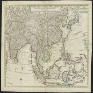

Royaume de Siam, avec les Royaumes qui luy sont Tributaires, et les Isles de Sumatra, Andemaon etc.
1742
Brunei, Cambodia, Indonesia, Laos, Malaysia, Myanmar, Singapore, Thailand, Vietnam
Map marking the routes through maritime Southeast Asia of two delegations: a French delegation from Brest, France to Siam in 1685; and a Siamese delegation from Siam to Brest in 1686. A note next to Aceh records a sea battle against Portugal in 1616.

L'Asie divisée en ses principales parties oú les Empires, Roïaumes, Etats et Peuples sont distingues les uns des autres
c.1740
Brunei, Cambodia, East Timor, Indonesia, Laos, Malaysia, Myanmar, Philippines, Singapore, Southeast Asia, Thailand, Vietnam
The southern coast of Borneo is labelled ‘Cote des Mahometans [Coast of the Muslims]’. A note next to the Philippines states that they were discovered by Ferdinand Magellan in 1520 and are comprised of about 11,000 islands.

L'Asie dressée sur les observations de Mrs. de l'Academie Royale de Sciences
1730
Brunei, Cambodia, East Timor, Indonesia, Laos, Malaysia, Myanmar, Philippines, Singapore, Southeast Asia, Thailand, Vietnam
This map features maritime routes: between Siam and Batavia; and five routes of the explorers Juan Gaetan and Olivier du Nord (dated 1542) east of the Philippines. The cartouche has a colourful illustration of Asian people in traditional costume.
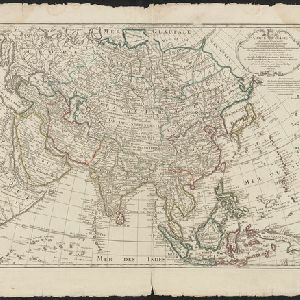
Carte d'Asie: dressée sur les memoires envoyéz par le Czar a l'Academie Royale des Science
1723
Brunei, Cambodia, East Timor, Indonesia, Laos, Malaysia, Myanmar, Singapore, Philippines, Southeast Asia, Thailand, Vietnam
An early 18th century map of Asia by the French cartographer Guillaume Delisle (1675–1726). Regions are indicated with coloured borders, and the southern part of Borneo is labelled ‘Côte de Mahometans [Coast of the Muslims]’.

Carte d'Asie: dressée sur les memoires envoyéz par le Czar a l'Academie Royale des Science
c.1722-1774
Brunei, Cambodia, East Timor, Indonesia, Laos, Malaysia, Myanmar, Philippines, Singapore, Southeast Asia, Thailand, Vietnam
An early 18th century map of Asia by the French cartographer Guillaume Delisle (1675–1726). Regions are indicated with coloured borders, and the southern part of Borneo is labelled ‘Côte de Mahometans [Coast of the Muslims]’.

Carte des Indes et de la Chine
c.1722-1774
Brunei, Cambodia, East Timor, Indonesia, Laos, Malaysia, Myanmar, Philippines, Singapore, Southeast Asia, Thailand, Vietnam
This map uses coloured borders to show the ancient kingdoms of Southeast Asia. A label on the island of Borneo states ‘Beajous Idolatres habitans le milieu de l'Isle [Beajous idolaters inhabit the middle of the Island]’.


