Search

Search Results

Schetskaart van het Toba-meer en aangrenzende landstreken

event1898

location_onIndonesia

Map of Lake Toba and the surrounding area in northern Sumatra, featuring mountains, forests, types of terrain (undergrowth, field, grass), rivers, roads and settlements. There is an inset map that shows the other maps referenced in producing the map.

Schetskaart van het terrein doorloopen bij de excursie in 1890 tegen de Battaksche landschappen Loemban-Pinasa en Djandji

event1891

location_onIndonesia

Map of an expedition route—in red—through the country of the Batak people of northern Sumatra, from Lake Toba to Loemban-Pinasa (Lumban Pinasa) and Djandji. Mountains and forests are shown, along with two drawings of views of hills.

Schetskaart der Pak Pak-landen

event1890

location_onIndonesia

Map of the lands of the Pakpak people, an ethnic group of Batak people of northern Sumatra. The names of various sub-ethnic groups—Siem Siem (Pakpak Simsim), Pegagan (Pakpak Pegagan), Kepas (Pakpak Keppas)—are marked to show their territories.

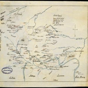
Schetskaart van het boven stroom gebied der Asahan rivier, aek Asahan en aek Bila

event1890

location_onIndonesia

Hand-drawn map of the upper basin of the Asahan River, just southeast of Lake Toba in northern Sumatra. Rivers such as the Hoewaloe and Bila are marked in blue, with roads in red, mountains shaded brown, and settlements named.

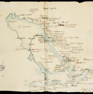
[Toba meer]

event1890

location_onIndonesia

A hand-drawn map of Lake Toba, northern Sumatra, marked with the route of an eight-day journey around the southern lake area—both on land and by boat—starting and ending in the town of Baligé.

close

  • Filter from 1890 to 1898

Current results range from 1890 to 1898