Search Results

A new chart of the eastern straits to China drawn from the best authorities
1800
Indonesia
Two maps of routes around the Flores and Banda seas—through the straits between the Lesser Sunda Islands and the Maluku Islands—towards China. Includes a rhumbline network—a web of lines to help plot routes—bathymetry (sea depth), shoals and reefs.

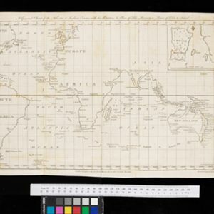
A general chart of the Atlantic and Indian oceans, with the situation & plan of Pulo Peenang or Price of Wales's Island / Plan of the Strait within Poolo Pinang
1788
Malaysia, East Timor, Indonesia, Papua New Guinea, Singapore
Two maps. One features most of the world, but with Borneo, Philippines and most of mainland Southeast Asia missing, though there is an inset map of Penang. The other is a navigation map of the strait at Penang, with bathymetry and elevations.

A map of Java, Borneo and the islands to the eastward of them as far as Nova Guinea
1744
Indonesia, East Timor
A simple mid-18th century map featuring Borneo, Java, Celebes (Sulawasi) and many other smaller islands as far as New Guinea to the east, and Timor to the south. The only details are the names of the islands and some larger settlements.
- Filter from 1744 to 1864
- [remove]Indonesia4
- East Timor2
- Malaysia1
- Papua New Guinea1
- Singapore1
- Java4
- [remove]Lesser Sunda Islands4
- Celebes3
- New Guinea3
- Sulawesi3
- Bali2
- Borneo2
- Flores2
- Flores Sea2
- Java Sea2
- Lombok2
- Seram2
- more Detailed Location »


