
Search


Refine your results
- check_box[remove]Bodleian Libraries, University of Oxford9
- Filter from 1701 to 1898
Current results range from 1701 to 1898
Location
- check_box_outline_blankPhilippines9
- check_box_outline_blankIndonesia7
- check_box_outline_blankMalaysia7
- check_box_outline_blankCambodia5
- check_box_outline_blankThailand5
- check_box_outline_blankVietnam5
- check_box_outline_blankBrunei4
- check_box_outline_blankLaos4
- check_box_outline_blankMyanmar4
- check_box_outline_blankSingapore4
- check_box_outline_blankEast Timor3
- check_box_outline_blankPapua New Guinea3
- more Simple Location »
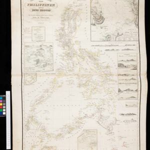
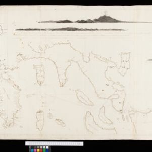
- check_box[remove]Luzon9
- check_box_outline_blankBorneo5
- check_box_outline_blankSiam5
- check_box_outline_blankCelebes4
- check_box_outline_blankJava4
- check_box_outline_blankMindanao4
- check_box_outline_blankSulawesi4
- check_box_outline_blankAracan3
- check_box_outline_blankMalay Peninsula3
- check_box_outline_blankPegu3
- check_box_outline_blankPhilippine Islands3
- check_box_outline_blankSulu Sea3
- more Detailed Location »
Land and Sea Routes
Cultural and Political Regions
Environmental Features
Insets and Attributes
Map Production Details
- check_box_outline_blankBerghaus, Heinrich Karl Wilhelm3
- check_box_outline_blankJohnston, Keith (A.K.)2
- check_box_outline_blankJohnston, William2
- check_box_outline_blankBrault, Louis Désiré Léon1
- check_box_outline_blankCamacho, Manuel M.1
- check_box_outline_blankDumas-Vorzet, Eduard1
- check_box_outline_blankRaynaud1
- check_box_outline_blankThornton, John1
- check_box_outline_blankWilliam Blackwood & Sons2
- check_box_outline_blankDépôt des Cartes et Plans de la Marine1
- check_box_outline_blankGeorge Philip & Son1
- check_box_outline_blankJohannes Loots1
- check_box_outline_blankJohannes van Keulen1
- check_box_outline_blankJustus Perthes1
- check_box_outline_blankW. & A.K. Johnston1


