
Search Results


Algemeene kaart van Nederlandsch Indië
1879
Cambodia, Indonesia, Papua New Guinea, East Timor, Southeast Asia, Thailand, Malaysia, Philippines, Laos, Vietnam, Singapore, Brunei, Myanmar
A late 19th century map of the Dutch East Indies on four sheets, detailing maritime routes around the region. There are also inset maps showing railways, rivers, roads, and telegraph systems, as well as individual islands and cities.

Nederlandsch Oost-Indië
1865
Brunei, Cambodia, East Timor, Indonesia, Laos, Malaysia, Myanmar, Vietnam, Thailand, Southeast Asia, Singapore, Philippines, Papua New Guinea
This detailed map of the Dutch East Indies in the mid-19th century contains a great deal of information: topographical details, settlements and administrative areas, roads, railways and maritime routes, telegraph lines, inset maps etc.

Zee- en landkaart waarop de dagelijksche vorderingen eener zeereis van Nederland naar N.O. Indië door een deskundig passagier naauwkeurig aangeteekend
c.1860
Brunei, Cambodia, East Timor, Indonesia, Laos, Malaysia, Myanmar, Philippines, Singapore, Southeast Asia, Thailand, Vietnam
Map of the Eastern Hemisphere featuring a maritime route from the Netherlands to the port of Batavia (Jakarta) in the East Indies, with each day’s progress marked. Other routes around the region and back to Europe via the Suez Canal are also shown.
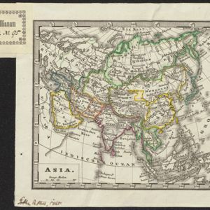
Asia
c.1845
Brunei, Cambodia, East Timor, Indonesia, Laos, Malaysia, Myanmar, Philippines, Singapore, Southeast Asia, Thailand, Vietnam
Map of Asia divided into regions with coloured borders. Mainland Southeast Asia is in green, and features the ancient kingdoms of Birma (Myanmar), Siam (Thailand) and An-nam (Vietnam).
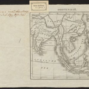
Oostindië
1842
Brunei, Cambodia, East Timor, Indonesia, Laos, Malaysia, Myanmar, Philippines, Singapore, Southeast Asia, Thailand, Vietnam
Dutch map of the East Indies, with mountain ranges represented by simple hachure marks, and just a few rivers marked. Mainland Southeast Asia is labelled ‘Achter Indie [Beyond India]’.

Nieuwe generale kaart van Asia: Volgens de laatste ontdekkingen van Cook
c.1780
Brunei, Cambodia, East Timor, Indonesia, Laos, Malaysia, Myanmar, Philippines, Singapore, Southeast Asia, Thailand, Vietnam
Map of Asia based—according to the subtitle—on discoveries by the British Royal Navy captain James Cook. It includes Batavia (Jakarta) where he visited in 1770, and the South China Sea through which his ship Resolution sailed after his death in 1779.
- Brunei23
- Cambodia23
- Indonesia23
- Laos23
- Malaysia23
- [remove]Myanmar23
- Philippines23
- Singapore23
- Thailand23
- Vietnam23
- East Timor19
- Southeast Asia19
- more Simple Location »
- [remove]Malakka23
- Borneo22
- Malay Peninsula22
- Siam22
- Sumatra22
- Java18
- Celebes16
- Sulawesi16
- Ava15
- Maluku Islands15
- Pegu11
- South China Sea11
- more Detailed Location »


