
Search Results

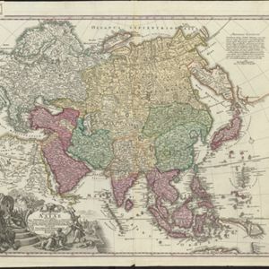
Recentissima Asiae Delineatio: Qua Imperia eius, Regn, et Status...
1730
Brunei, Cambodia, East Timor, Indonesia, Laos, Malaysia, Myanmar, Papua New Guinea, Singapore, Philippines, Southeast Asia, Thailand, Vietnam
This map's cartouche features an illustration of three men bowing before a ruler on a throne. There is also what was probably meant to be a lion, though the poor likeness suggests it was based on written descriptions rather than real life experience.
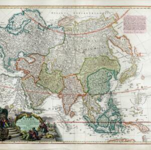
Asiae recentissima delineatio, qua Status et Imperia totius Orientis unacum Orientalibus Indiis exhibentur
1730
Vietnam, Myanmar, Papua New Guinea, Philippines, Singapore, Southeast Asia, Thailand, Malaysia, Laos, Indonesia, East Timor, Cambodia, Brunei
This map's cartouche features an illustration of three men bowing before a ruler on a throne. There is also what was probably meant to be a lion, though the poor likeness suggests it was based on written descriptions rather than real life experience.

Asiae recentissima delineatio, qua Status et Imperia totius Orientis unacum Orientalibus Indiis exhibentur
1720
Brunei, Cambodia, East Timor, Indonesia, Laos, Malaysia, Myanmar, Philippines, Singapore, Southeast Asia, Thailand, Vietnam
This map's cartouche features an illustration of three men bowing before a ruler on a throne. There is also what was probably meant to be a lion, though the poor likeness suggests it was based on written descriptions rather than real life experience.

Asia
1700
Brunei, Cambodia, East Timor, Indonesia, Laos, Malaysia, Myanmar, Philippines, Singapore, Southeast Asia, Thailand, Vietnam
Unusually, on this map of Asia, the place name Campa is used to label a large part of mainland Southeast Asia. In fact, Campa (more often Champa) was a smaller kingdom on the southeast coast of the mainland (part of modern Vietnam).
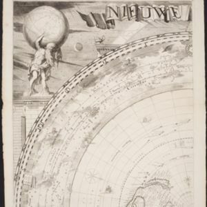
Platte globus van hemel en aarde noyt alsoo gesien waar op heel licht kan geleert worden d'loop des hemels en zee-vaart op alle polus-hooghten
1697
Brunei, Cambodia, Indonesia, Laos, Malaysia, Myanmar, Philippines, Southeast Asia, Thailand, Vietnam, Singapore, East Timor
A richly illustrated circular map of the world, surrounded by a ring of stars and sky, and spread over four sheets. The corners contain drawings of Atlas and Hercules holding the Earth on their shoulders, and of various philosophers and astronomers.

L'Asia
1677
Brunei, Cambodia, East Timor, Indonesia, Laos, Malaysia, Myanmar, Philippines, Southeast Asia, Singapore, Thailand, Vietnam
From Giovanni Giacomo de Rossi’s ‘Mercurio Geografico’, this 17th century map of Asia represents mountains, jungles and cities pictorially, with hand-coloured regional borders. The map’s cartouche is decorated with clothing and weaponry.
- Filter from 1677 to 1890
- Brunei11
- Cambodia11
- East Timor11
- Indonesia11
- Laos11
- Malaysia11
- Myanmar11
- [remove]Philippines11
- Singapore11
- Southeast Asia11
- Thailand11
- Vietnam11
- more Simple Location »
- Borneo11
- Java11
- [remove]N. Guinea11
- Sumatra11
- Celebes10
- Malacca10
- Malay Peninsula10
- Sulawesi8
- Pegu7
- Siam7
- Maluku Islands6
- Aracam5
- more Detailed Location »


