Search

Search Results

Carte Réduite des Terres Australes = Gereduceerde Kaart van 't Zuid-Land

event1758

location_onIndonesia, Papua New Guinea

New Guinea is shown connected to Australia (‘Nouvelle Hollande’) on this mid-18th century map. The title’s ‘Terres Australes’ means ‘southern lands’ indicating how Australia was named. The text is in French, with the title also in Dutch at the base.

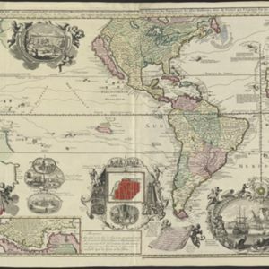
Carte nouvelle de la Mer du Sud

event1730

location_onEast Timor, Indonesia, Papua New Guinea, Philippines, Vietnam

This elaborately illustrated map of the Atlantic and Pacific Oceans includes the eastern islands of Southeast Asia. The routes of five expeditions west across the Pacific are marked, including that of Ferdinand Magellan to the Philippines in 1520.

Hemisphere oriental: dressé en 1720 pour l'usage particulier du Roy sur les observations astronomiques et geographiques

event1724

location_onBrunei, Cambodia, East Timor, Indonesia, Laos, Malaysia, Myanmar, Papua New Guinea, Philippines, Singapore, Southeast Asia, Thailand, Vietnam

This map of the Eastern Hemisphere (Asia, Europe, Africa) shows New Guinea (‘Nouvelle Guinee’) and Australia (‘Nouvelle Hollande’) as one landmass, demonstrating that there was some uncertainty about the area’s geography in the early 18th century.

L'Asie divisée en ses principales regions, et ou se peuvent voir l'estendue des Empires, Monarchies, Royaumes, et Estats qui partagent présentement l'Asie

event1720

location_onBrunei, Cambodia, East Timor, Indonesia, Laos, Myanmar, Malaysia, Papua New Guinea, Philippines, Singapore, Southeast Asia, Vietnam, Thailand

This map shows the empires, kingdoms and states of Southeast Asia. Its decorative cartouche features drawings of two women—one with a cornucopia and one with a censer (incense burner)—elephant heads, and a French coat of arms. Nine scales are shown.

L'Asie divisée en ses principales regions, et ou se peuvent voir l'estendue des Empires, Monarchies, Royaumes, et Estats qui partagent présentement l'Asie

event1720

location_onBrunei, Cambodia, East Timor, Indonesia, Laos, Malaysia, Myanmar, Papua New Guinea, Philippines, Singapore, Southeast Asia, Thailand, Vietnam

This map shows the empires, kingdoms and states of Southeast Asia. Its decorative cartouche features drawings of two women—one with a cornucopia and one with a censer (incense burner)—elephant heads, and a French coat of arms. Nine scales are shown.

L'Asie divisée en ses principales regions, et ou se peuvent voir l'estendue des Empires, Monarchies, Royaumes, et Estats qui partagent présentement l'Asie

eventc.1700

location_onBrunei, Cambodia, East Timor, Indonesia, Laos, Malaysia, Myanmar, Papua New Guinea, Philippines, Singapore, Southeast Asia, Thailand, Vietnam

This map shows the empires, kingdoms and states of Southeast Asia. Its decorative cartouche features drawings of two women—one with a cornucopia and one with a censer (incense burner)—elephant heads, and a French coat of arms. Nine scales are shown.

L'Asie divisée en ses principales regions, et ou se peuvent voir l'estendue des Empires, Monarchies, Royaumes, et Estats qui partagent présentement l'Asie

event1696

location_onBrunei, Cambodia, East Timor, Indonesia, Laos, Malaysia, Myanmar, Papua New Guinea, Philippines, Singapore, Southeast Asia, Thailand, Vietnam

This map shows the empires, kingdoms and states of Southeast Asia. Its decorative cartouche features drawings of two women—one with a cornucopia and one with a censer (incense burner)—elephant heads, and a French coat of arms. Nine scales are shown.

Les Isles Molvcqves; Celebes, Gilolo, &c.

event1652

location_onIndonesia, East Timor, Papua New Guinea

This map of the islands between Borneo and New Guinea features inset maps of the important spice trading islands (‘Spice Islands’): ‘Les Isles Molucques’ (Maluku Islands) and ‘Isles de Banda’ (Banda Islands).

close