Search

Search Results

Westkust Sumatra: Padang tot Vlakkehoek

event1898

location_onIndonesia

Navigation map of the west coast of Sumatra, including the cities of Padang and Bengkulu, and the Mentawai islands. Bathymetry (sea depth), lighthouses, shoals and other obstructions are marked, with hills and settlements to use as landmarks.

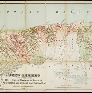
Landbouw-ondernemingen in de afdeelingen Deli, Batoe Bahara en Asahan (Residentie Oostkust van Sumatra)

event1898

location_onIndonesia

On this map of the east coast of northern Sumatra, red borders divide the land into agricultural properties, each with a number to identify it. The whole area is divided into colour-coded administrative districts.

Atlas van Nederlandsch Oost-Indië

eventc.1897-1904

location_onIndonesia

Very detailed atlas of the entire Dutch East Indies, over 16 map sheets, with a cover and overview map. Includes topographic maps, inset maps of cities and islands, and maps featuring land and sea routes, languages, geology, colonial territory etc.

Oostkust Sumatra: Blad VII

event1896

location_onIndonesia

Navigation map of the waters around the islands of Bengkalis, Pedang and Tebingtinggi, off the east coast of Sumatra. Bathymetry (sea depth), tide data, reefs, shoals and other obstructions (clay, mud, shells, sand) are marked.

Koninginne baai met Emma haven

event1894

location_onIndonesia

Map of Koninginne Baai (Bayur Bay, west coast of Sumatra) used to navigate Emma Haven (now Port of Teluk Bayur). It features bathymetry (sea depth), reefs and shoals, as well as lighthouses, buoys and two elevations (side views) of coastal mountains.

Schetskaart van een gedeelte van Midden Sumatra

event1891

location_onIndonesia

A map of central Sumatra spread over four sheets, divided into administrative districts, and with roads, railways and settlements marked. An inset map acts as a locator map, showing the main map’s location within Sumatra.

Kaart van het middengedeelte van Sumatra

event1890

location_onIndonesia

Details of each area’s resources are printed on this map of Sumatra: rattan, coffee, pepper, Chinese cinnamon, tobacco, resins, camphor, cotton, coal, gold, lumber, elephants, horses, as well as the locals’ ethnicity (Malays, Javanese, Acehnese).

Kaart van een gedeelte der Westkust van Sumatra

event1855

location_onIndonesia

Hachures—short lines/dashes that give a sense of the shape and steepness of terrain—are used to show the mountains of Sumatra’s west coast, and of the Padang Highlands and Lowlands. Text lists the heights of some of the region’s chief mountains.

close

  • Filter from 1855 to 1898

Current results range from 1855 to 1898