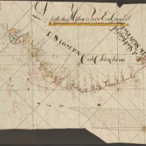
Suite du plan contenant depuis Camboya, Cochinchine jusques à Canton avec les Isles Aimant et Philipines
c.1750
Cambodia, Philippines, Vietnam
Map of the South China Sea between mainland Southeast Asia and the Philippines. Shoals and reefs, especially the Paracel Islands (‘Poulo Parcellas’), are shown. Bathymetry (sea depth) is indicated by the numbers marked along coastal routes.