Search

Search Results

Kaart van 't noordwestelijke gedeelte der Residentie Ambon

event1898

location_onIndonesia

Map of the residency of Ambon in the Maluku Islands, divided by colour-coded administrative borders. There are inset maps the Banda Islands—including the nutmeg plantations and the town of Neira with its fort and hospital—and of Dutch New Guinea.

Kaart der Molukken

event1898

location_onIndonesia, East Timor

Map of the Moluccas (Maluku Islands) divided into the residencies of Ternate (orange borders) and Ambon (green borders). Many place names are in Dutch and Malay, and there is an inset map of the city of Ambon. Timor is marked as Portuguese territory.

Kaart van het Midden-en Zuidelyk Gedeelte van den Molukschen Archipel

event1854

location_onIndonesia, East Timor

Map of some of the Maluku islands around the Banda Sea, colour-coded by their administrative region, and with an elevation showing heights of mountains. (From ‘Algemeene Atlas van Nederlandsche Indie [General Atlas of the Dutch East Indies]’.)

Kaart van Amboina en eenige aangrenzende eilanden

event1854

location_onIndonesia

Map of Amboina (Ambon) and surrounding islands just south of Ceram (Seram). An elevation (side view) of the islands shows the heights of their mountains. (From ‘Algemeene Atlas van Nederlandsche Indie [General Atlas of the Dutch East Indies]’.)

Kaart der Nederlandsche Bezittingen of het Eiland Nieuw-Guinea

event1853

location_onIndonesia

Map of Dutch colonial territory in New Guinea and nearby islands, featuring the 1850 route of the Dutch schooner Circe under Lieutenant Brutel de la Rivière. (From ‘Algemeene Atlas van Nederlandsche Indie [General Atlas of the Dutch East Indies]’.)

New Holland and Asiatic Isles

event1829

location_onIndonesia, East Timor, Papua New Guinea

Includes part of maritime Southeast Asia. New Guinea is labelled as ‘discovered in 1527’—a reference to the Portuguese explorer Jorge de Menezes—with additional labels describing the terrain (‘Very low land’, ‘Coast is not well known’, ‘An Opening’).

New Holland and Asiatic Isles

event1814

location_onIndonesia, East Timor, Papua New Guinea

Includes part of maritime Southeast Asia. New Guinea is labelled as ‘discovered in 1527’—a reference to the Portuguese explorer Jorge de Menezes—with additional labels describing the terrain (‘Very low land’, ‘Coast is not well known’, ‘An Opening’).

A new chart of the eastern straits to China drawn from the best authorities

event1800

location_onIndonesia

Two maps of routes around the Flores and Banda seas—through the straits between the Lesser Sunda Islands and the Maluku Islands—towards China. Includes a rhumbline network—a web of lines to help plot routes—bathymetry (sea depth), shoals and reefs.

De landvoogdy van Amboina met de elf onderhoorige eylanden

event1726

location_onIndonesia

Although mainly a navigation map—with a rhumbline network and elevations of mountains—there are also many terrestrial details shown, such as settlements and mountains. The inset map of Hoeamohel details plantations and the cultivation of nut crops.

[Dutch portolan chart of the eastern Dutch East Indies]

event1700

location_onIndonesia, East Timor

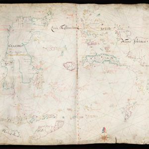
This colourful hand-drawn portolan (nautical) chart was designed to aid navigation. It features a rhumbline network (the web of interconnected lines), bathymetry (sea depth), shoals and reefs, anchor points and written notes.

Insulæ Indiæ orientalis

event1690

location_onBrunei, Cambodia, East Timor, Indonesia, Laos, Malaysia, Myanmar, Philippines, Singapore, Southeast Asia, Thailand, Vietnam

The southern coast of Java ('Iava Maior') on this map is represented by a dotted line, indicating that the exact coastline was unknown at this time. Italian text on the reverse describes the Maluku Islands including Ambon, Banda and Ternate.

Asiae nova descriptio

event1653

location_onBrunei, Cambodia, East Timor, Indonesia, Laos, Malaysia, Myanmar, Philippines, Southeast Asia, Singapore, Thailand, Vietnam

A mid-17th century map of Asia decorated with a border of drawings of Asian cities and Asian rulers, including the port of Bantam (Banten) at the western end of Java, and a portrait of ‘Rex Moluccae’ the ‘king’ of the Moluccas (Maluku Islands).

close