Search

Search Results

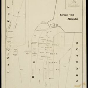
Schetskaart van de Deli-ondernemingen in 1875

event1880

location_onIndonesia

Map of Deli on the northeast coast of Sumatra, divided into parcels of land which are labelled—in capital letters—with the names of businesses. Place names are in lowercase. The coast, rivers and land parcels are rendered in simple straight lines.

Schetskaart van het N.W. gedeelte der Residentie Sumatra's Oostkust

event1877

location_onIndonesia

Rivers and crops are the focus of this map of the northeast coast of Sumatra. Forests and wetlands are marked, as are alang-alang, coconut, pepper, nutmeg and tobacco. Roads are shown as suitable for infantry and light artillery, or for horse riding.

close

  • Filter from 1877 to 1880

Current results range from 1877 to 1880