Search

Search Results

Isole dell'Indie divise in Filippine, Molucche e della Sonda

event1680

location_onBrunei, Cambodia, East Timor, Indonesia, Malaysia, Laos, Myanmar, Philippines, Singapore, Southeast Asia, Thailand, Vietnam

Dotted lines and colours divide maritime Southeast Asia into three regions on this map: the Philippine archipelago, Maluku Islands and Sunda Islands. The cartouche features cherub mermaids, and a map of mainland Southeast Asia is on the reverse.

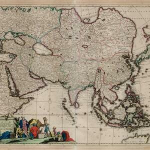
Exactissima Asiae delineatio, in praecipuas regiones, ceterasq partes divisa

event1680

location_onBrunei, Cambodia, East Timor, Indonesia, Laos, Malaysia, Myanmar, Philippines, Singapore, Southeast Asia, Thailand, Vietnam

The cartouche on this late 17th century map of Asia features a colourful illustration of Asian traders negotiating a deal. In the background, their workers carry packages and tend to a camel.

Accuratissima totius Asiæ tabula: Recens emendata

event1680

location_onBrunei, Cambodia, East Timor, Indonesia, Laos, Malaysia, Myanmar, Philippines, Singapore, Southeast Asia, Thailand, Vietnam

A detailed late 17th century map of Asia, showing ancient kingdoms and the place names of important settlements. The cartouche features a drawing of Asian traders selling their goods, while a camel, monkey and two birds look on.

The isles of Sonda

event1680

location_onBrunei, Indonesia, Malaysia, Singapore

From Robert Morden’s ‘Geography Rectified’, a description with maps of the known world in the late 17th century. Text describes the peoples of the uplands of the Sunda Islands as ‘Pagans’, while the coastal peoples are ‘Mahumetans [Muslims]’.

close