Search

Search Results

An Accurate map of India beyond the Ganges with the oriental islands, generally called East India

event1780

location_onBrunei, Cambodia, East Timor, Indonesia, Laos, Malaysia, Myanmar, Philippines, Singapore, Southeast Asia, Thailand, Vietnam

This map uses colour to identify regions in late 18th century Southeast Asia, many of which roughly correspond to modern countries: Pegu=Myanmar, Tonkin/Cochin China=Vietnam, Lao =Laos, Siam=Thailand, Malaya=Malaysia, Philippin Islands=Philippines.

I. Timor

event1780

location_onIndonesia

The many navigation aids marked on this map, including bathymetry (sea depth), anchor points, shoals, and elevations of hills, were designed to guide ships around this part of the west coast of Timor. The Dutch fort Concordia is also marked.

A map of Java, Borneo and the islands to the eastward of them as far as Nova Guinea

event1744

location_onIndonesia, East Timor

A simple mid-18th century map featuring Borneo, Java, Celebes (Sulawasi) and many other smaller islands as far as New Guinea to the east, and Timor to the south. The only details are the names of the islands and some larger settlements.

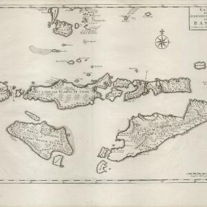
Kaart der Zuyd-Wester Eylanden van Banda

eventc.1724-1726

location_onEast Timor, Indonesia

Although this map’s title refers to the south-western islands of the Banda Islands, it actually focuses on the Lesser Sunda Islands, including Flores, Sumba and Timor. The islands feature mountains and jungle, with shoals and reefs around the coasts.

Isle Molvcqves

event1684

location_onIndonesia

The islands on this map were central to conflicts between the European powers over the valuable spice trade of the Maluku or ‘Spice’ Islands. A sea battle between European ships is shown, and there are military forts marked in red on the islands.

Isole Molvcche

event1605

location_onBrunei, Cambodia, Indonesia, Laos, Malaysia, Philippines, Singapore, Southeast Asia, Thailand, Vietnam, East Timor

This map shows some inaccuracies, especially in the shape of the Malay Peninsula and the islands meant to represent Sumatra (labelled ‘Camatra’), Java (‘Iava Mazor’) and Borneo (‘Iava Menor’). Latin text describes the Maluku Islands.

Tabula orientalis regionis, Asiae scilicet extremas complectens terras et regna

event1545

location_onBrunei, Cambodia, East Timor, Indonesia, Laos, Malaysia, Myanmar, Philippines, Singapore, Southeast Asia, Thailand, Vietnam

This 1550 map by the German cartographer Sebastian Münster (1488–1552) was based on the work of the 2nd century geographer Ptolemy. There are many inaccuracies, especially in scale and the locations of mountain ranges, but the region is recognisable.

India extrema, XIX nova tabvla

event1540

location_onBrunei, Cambodia, East Timor, Indonesia, Laos, Malaysia, Myanmar, Philippines, Singapore, Southeast Asia, Thailand, Vietnam

This 1540 map by the German cartographer Sebastian Münster (1488–1552) was based on the work of the 2nd century geographer Ptolemy. On the reverse, there is Latin text giving details of the area, including crops grown.

close

  • Filter from 1540 to 1780

Current results range from 1540 to 1780