Search

Search Results

Nieuwe kaart van het eiland Java

event1816

location_onIndonesia

Map of Java marked with administrative regions, settlements, roads, mountains and rivers. There is an inset map of the port city of Batavia, with its system of rivers and canals, and its surrounding country with villages, fields and plantations.

Plan de l'île de Java

eventc.1800-1820

location_onIndonesia

Map of Java divided into Dutch colonial administrative areas and the Mataram Sultanate (‘Pays de l'Empereur et du Sultan du Mataram entre melés [Country of the Emperor and the Sultan of Mataram mixed]’. The map is orientated with south at the top.

Kaart van het eiland Groot Java

event1798

location_onIndonesia

Map of Java divided into administrative areas. Mountains are shown pictorially, major rivers are named, and the coasts have shoals. The map is orientated with south at the top, so the island looks ‘upside down’ compared to how it is usually shown.

Carte des Isles de la Sonde et du Détroit de Malaca

event1791

location_onBrunei, Indonesia, Malaysia, Singapore

Map based on the expeditions of Jean-François de Surville, a merchant captain with the French East India Company. Some details are from the diary of the French Navy officer Théobald René, Comte de Kergariou-Locmaria, who explored the region in 1785.

Carte de l'Isle de Java, avec les isles de Banca, de Billiton, et une partie de celles de Sumatra et de Borneo

event1775

location_onIndonesia

This 18th century maritime navigation map charts the waters between the islands of Java, Sumatra and Borneo. A route south towards the Sunda Strait, as taken by the French ship Mascarin in March and April 1772, is highlighted.

Nouvelle Carte de l'isle de Java

eventc.1772-1780

location_onIndonesia

On this map of Java, mountains are shown pictorially and labelled with their name. The coasts are marked with shoals, reefs, bathymetry (sea depth, in figures) and anchor points. The land is divided into administrative districts.

Carte de l'isle Celebes ou Macassar

event1763

location_onIndonesia

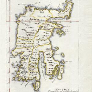
This mid-18th century map of Celebes (Sulawasi) shows the island divided into approximately a dozen separate kingdoms. The Gulf of Saleyer is noted as being ‘rempli de Bancs de Sable [filled with sandbanks]’.

close