
Search Results

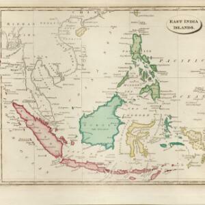
East India islands
1810
Brunei, Cambodia, East Timor, Indonesia, Laos, Malaysia, Myanmar, Philippines, Singapore, Southeast Asia, Thailand, Vietnam
The islands of maritime Southeast Asia are highlighted in different colours on this early 19th century map. Major rivers, straits and seas are also named.
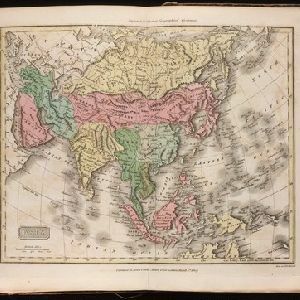
Asia. Engraved for Evans's Geographical Grammar
1809
Brunei, Cambodia, East Timor, Indonesia, Laos, Malaysia, Myanmar, Papua New Guinea, Philippines, Singapore, Southeast Asia, Thailand, Vietnam
This early 19th century map depicts the regions of Asia by colour. The continental regions are green, while the archipelago regions are red, except for New Guinea which is yellow.

The continent and islands of Asia: with all the latest discoveries
1809
Vietnam, Myanmar, Papua New Guinea, Philippines, Singapore, Southeast Asia, Thailand, Malaysia, Laos, Indonesia, East Timor, Cambodia, Brunei
Southeast Asia is on the last sheet of this map of Asia. The South China Sea is labelled ‘Malayan Sea’. Small islands, shoals and reefs are shown. A label in Cochin China (Vietnam) reads ‘mountains inhabited by the uncivilized people called Kemoys’.


Chart of Pulo Penang: now Prince of Wales's Island
1805
Malaysia
Map focusing on the passage between Penang Island and the mainland, with shoals and reefs marked and described, and bathymetry (sea depth) shown. There are anchor points at George Town harbour, and landmarks—hills, trees, a fort—to aid navigation.

Carte de l'Archipel des Indes Orientales, représentant les différens passages entre l'Ocean Indien et le Grand Océan
c.1804
Brunei, Cambodia, East Timor, Indonesia, Laos, Malaysia, Myanmar, Philippines, Singapore, Southeast Asia, Thailand, Vietnam
Map focusing on the passages between the islands of maritime Southeast Asia used to travel between the Indian and Pacific oceans. Includes the Strait of Malacca, many straits between the Sunda Islands, and a route through the Maluku Islands.

A new map of the East India Isles
1801
Brunei, Cambodia, East Timor, Indonesia, Laos, Malaysia, Myanmar, Vietnam, Thailand, Southeast Asia, Singapore, Philippines
An early 19th century map by the English cartographer John Cary, highlighting the mountain ranges and rivers of Southeast Asia. The map also features many place names of cities, towns and islands.

The Eastern Hemisphere
1801
Myanmar, Brunei, Cambodia, East Timor, Indonesia, Laos, Malaysia, Vietnam, Thailand, Southeast Asia, Singapore, Philippines
Published by the English cartographer John Cary (c.1754–1835), this map is marked with the routes taken from Europe to Asia by the British Royal Navy captains James Cook, John Gore, and George Vancouver, as well as the French explorer Lapérouse.

Charte de l'Asie
1800
Brunei, Cambodia, East Timor, Indonesia, Laos, Malaysia, Myanmar, Papua New Guinea, Philippines, Singapore, Southeast Asia, Thailand, Vietnam
The cartouche on this early 19th century map of Asia features a drawing of an Asian merchant smoking a long pipe while standing with his goods. Behind are a camel and an elephant surrounded by greenery and palm trees.
- Filter from 1478 to 1900
- English220
- French214
- Latin194
- Dutch133
- German85
- Italian21
- Spanish2
- Portuguese1
- more Language »
- [remove]Malaysia802
- Indonesia737
- Singapore693
- Thailand648
- Brunei624
- Cambodia622
- Vietnam613
- Myanmar598
- Philippines579
- Laos573
- East Timor532
- Southeast Asia522
- more Simple Location »
- Sumatra670
- Borneo632
- Malay Peninsula581
- Java563
- Sulawesi485
- Celebes408
- Siam333
- Western New Guinea331
- Maluku Islands320
- Malacca264
- Sunda Islands256
- South China Sea246
- more Detailed Location »


