
Search Results

Nederland en deszelfs koloniën
1844
Brunei, East Timor, Indonesia, Malaysia, Singapore
Map of the East Indies, with the borders of Dutch colonial territory marked in brown. The Malay Peninsula (‘Malakka’) has green borders, indicating it is a British possession. Four inset maps show other Dutch territories outside Southeast Asia.

East India Islands
c.1844-1846
Brunei, Cambodia, East Timor, Indonesia, Laos, Malaysia, Myanmar, Philippines, Singapore, Southeast Asia, Thailand, Vietnam
From ‘Lizars' Edinburgh Geographical General Atlas’, this mid-19th century map was based on an earlier map by the English cartographer John Cary. It highlights the mountain ranges and rivers of Southeast Asia, and also features many place names.

Nederland en deszelfs koloniën
1844
Brunei, East Timor, Indonesia, Malaysia, Singapore
Map of the East Indies, with the borders of Dutch colonial territory marked in brown. The Malay Peninsula (‘Malakka’) has green borders, indicating it is a British possession. Four inset maps show other Dutch territories outside Southeast Asia.

Kaart van Nederlands Oostindische bezittingen
1843
Malaysia, Singapore, Indonesia, East Timor
Map of Dutch colonial possessions in maritime Southeast Asia, labelled with the names of administrative areas. Mountains are represented by hachures, short lines/dashes that give a sense of the shape and steepness of terrain.

Ethnographical Map of Asia in the earliest times, illustrative of Dr. Prichard's Natural History of Man
1843
Brunei, Cambodia, Indonesia, Laos, Malaysia, Myanmar, Philippines, Singapore, Thailand, Vietnam, Southeast Asia
Based on the British ethnologist James Cowles Prichard’s book ‘Natural History of Man’, this map shows the location of ethnicities in Asia. In Southeast Asia, the races are listed as ‘Arakan’, ‘Pegu’, ‘Thay or Siamese’, ‘Anam’ and ‘Pelagian’.
Kaart van Nederlands Oostindische bezittingen
1843
Malaysia, Singapore, Indonesia, East Timor
Map of Dutch colonial possessions in maritime Southeast Asia, labelled with the names of administrative areas. Mountains are represented by hachures, short lines/dashes that give a sense of the shape and steepness of terrain.

Map of the Burman Empire including also Siam, Cochin-China, Ton-king and Malaya
1842
Vietnam, Malaysia, Myanmar, Cambodia, Thailand, Laos, Indonesia, Singapore, Brunei
Although this mid-19th century map covers all of mainland Southeast Asia, the Burman Empire (Myanmar) is shown in greater detail, especially its districts, rivers and place names. It was produced by the James Wyld, geographer to Queen Victoria.

Map of India: shewing the British possessions in the year 1842
1842
Indonesia, Singapore, Thailand, Cambodia, Myanmar, Malaysia
A mid-19th century map colour-coded with British, French, Portuguese, Danish and Dutch colonial possessions in India and western Southeast Asia, as well as the ‘Native States’. A table lists the dates when the British acquired each area.
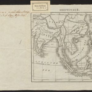
Oostindië
1842
Brunei, Cambodia, East Timor, Indonesia, Laos, Malaysia, Myanmar, Philippines, Singapore, Southeast Asia, Thailand, Vietnam
Dutch map of the East Indies, with mountain ranges represented by simple hachure marks, and just a few rivers marked. Mainland Southeast Asia is labelled ‘Achter Indie [Beyond India]’.

Kaart van de Nederlandsche bezittingen in Oost-Indië
1842
Brunei, East Timor, Indonesia, Malaysia, Philippines, Singapore
This map shows the Dutch colonial possessions in the East Indies in the mid-19th century. Other country’s colonial territories are also shown: British (Malacca), Spanish (Philippines) and Portuguese (East Timor). Forts are also marked.

- Filter from 1478 to 1900
- English185
- French183
- Latin178
- Dutch115
- German75
- Italian21
- Spanish2
- Portuguese1
- more Language »
- [remove]Singapore705
- Malaysia693
- Indonesia676
- Brunei600
- Thailand599
- Cambodia586
- Vietnam574
- Myanmar556
- Philippines556
- Laos548
- East Timor522
- Southeast Asia514
- more Simple Location »
- Sumatra644
- Borneo590
- Java550
- Malay Peninsula524
- Sulawesi472
- Celebes400
- Western New Guinea326
- Maluku Islands314
- Siam308
- Sunda Islands253
- Malacca247
- South China Sea233
- more Detailed Location »


