Search

Search Results

Asie divisée en ses Empires, Royaumes et Etats

event1794

location_onBrunei, Cambodia, East Timor, Indonesia, Laos, Malaysia, Myanmar, Philippines, Singapore, Southeast Asia, Thailand, Vietnam

This map of Asia features a decorative cartouche with drawings of two women—one with a cornucopia and one with a censer (incense burner)—and a French coat of arms. Interestingly, the map is dated 1792, during the French Revolution.

La nouvelle grande carte des Indes Orientales

event1792

location_onCambodia, Laos, Myanmar, Philippines, Thailand, Vietnam

Map of mainland Southeast Asia divided into kingdoms. Larger settlements are marked pictorially with a red building symbol. The desert of Cochinchine (Vietnam) is labelled as being inhabited by the ‘Kemoys Peuples Barbares [Kemoys Barbarian People]’.

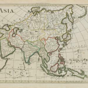
Asia / engraved for Walkers Geography &c.

event1792

location_onBrunei, Cambodia, East Timor, Indonesia, Laos, Malaysia, Myanmar, Papua New Guinea, Philippines, Singapore, Southeast Asia, Thailand, Vietnam

Hand-drawn coloured borders have been added to this map to distinguish various regions: mainland Southeast Asia and most of the islands of maritime Southeast Asia are bordered in green, with Borneo and the Philippines in red.

close