Search

Search Results

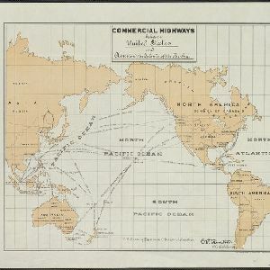
Commercial highways between United States and Asia and the islands of the Pacific

event1900

location_onBrunei, Cambodia, East Timor, Indonesia, Laos, Malaysia, Myanmar, Papua New Guinea, Philippines, Singapore, Southeast Asia, Thailand, Vietnam

The United States Treasury Department produced this map of trade routes crossing the Pacific Ocean between the United States and Asia. Each route is labelled with the names of its ports, and with the distance between them in miles.

Sketch showing positions of 1st Brigade, 2nd Division, 8th Corps, in operations against Manila

event1900

location_onPhilippines

Created by the U.S. Army, this map of a small area south of Manila records Spanish and American trenches and troop and gun locations on the last day of the Spanish–American War (13 August 1898). Ground conditions (swamps, jungle, fields) are noted.

Map of the Spanish and American trenshes on the south of Manila

eventc.1900-1909

location_onPhilippines

Created by the U.S. Army during the Spanish-American War, this reconnaissance map of a small area south of Manila features Spanish (red) and American (blue) trenches, as well as roads, buildings and ground conditions (firm ground, swamps, fields).

Manila, sus arrabales

event1898

location_onPhilippines

A late 19th century plan of the city of Manila, Philippines, showing the streets and buildings—categorised as military, civil or religious—around the Pasig River. The city is surrounded by suburbs, fields and wetlands.

Copy of map furnished to commanding officers, 2nd Brig., 2nd Div., 8th Army Corps, on August 12, 1898

event1898

location_onPhilippines

Created by the U.S. Army during the Spanish-American War, this reconnaissance map of a small area south of Manila features Spanish (red) and American (blue) trenches, as well as roads, buildings and ground conditions (firm ground, swamps, bamboo).

close

  • Filter from 1898 to 1900

Current results range from 1898 to 1900