Search

Search Results

Sumatra: Residentie Benkoelen (Bengkoelen)

eventc.1894-1895

location_onIndonesia

Map of the residency of Benkoelen (Bengkulu, southwest coast of Sumatra), over 10 sheets, with an inset map of the city of Bengkoelen (Bengkulu). Types of crops—coconut, rice, alang-alang, nipah palm, coffee—are marked. Sheet number 8 is missing.

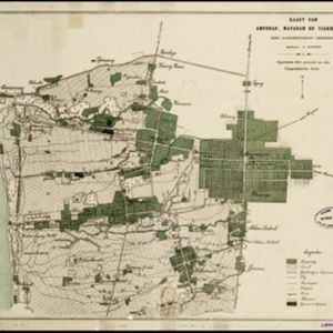
Kaart van Ampenan, Mataram en Tjakranagara met aangrenzend terrein

event1895

location_onIndonesia

A map of Mataram in the late 19th century showing it as a kampong (village) surrounded by paddy fields (rectangular parcels of land for growing rice). The map’s whole area is now just part of what is the largest city on the island on Lombok.

Hoofdplaats-Medan

event1895

location_onIndonesia

Map of the city of Medan on the north coast of Sumatra, featuring the Deli and Babura rivers and two railway lines. Other notable locations include a race track, military camp, Sultan’s palace (Maimun Palace), police station, offices, hospitals etc.

close