Search

Search Results

Insularum Indiæ orientalis nova descriptio

eventc.1700

location_onBrunei, Cambodia, East Timor, Indonesia, Laos, Malaysia, Myanmar, Philippines, Singapore, Southeast Asia, Thailand, Vietnam

The outline of the island of New Guinea is very vague on this early 17th century map of Southeast Asia. The cartouche is decorated with two figures of Asian warriors: one holds a spear, the other a sword. There are also drawings of mermaids.

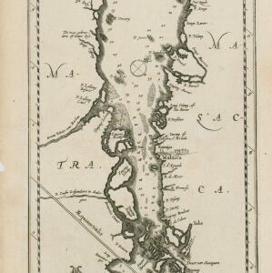
Le Détroit de Malacca: dressé sur les memoires des plus savans Voyageurs modernes

eventc.1700-1799

location_onMalaysia, Indonesia, Singapore

This 18th century map was designed to aid navigation through the Strait of Malacca between Sumatra and the Malay Peninsula. Shoals, reefs and islands are marked, and the numbers printed on the strait record sea depth (bathymetry).

Inde orientale

eventc.1700-1799

location_onBrunei, Cambodia, Indonesia, Laos, Malaysia, Myanmar, Philippines, Thailand, Vietnam

Four long rivers flow south through mainland Southeast Asia on this map: the ‘Menan’, ‘Manthabam’ and ‘Cosmin’ originate at a mythical lake (‘Chiamai Lac’) in southern China, while the ‘Mecon’ (Mekong) flows from the hills of Cochinchina (Vietnam).

close