Search

Search Results

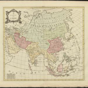
2e. carte de l'Asie

event1755

location_onBrunei, Cambodia, East Timor, Indonesia, Laos, Malaysia, Myanmar, Philippines, Singapore, Southeast Asia, Thailand, Vietnam

Mid-18th century French-language map of Asia, with Southeast Asia divided into four regions: the mainland in yellow, the Philippines in green, the Sunda Islands in red, and the Maluku Islands in yellow.

Carte du Cours de la Riviere de Tunquin: depuis Cacho jusqu'à La Mer

event1755

location_onVietnam

Map of the Tunquin River (Red or Hong River) from the city of Cacho (Hanoi, Thailand) to its mouth. At the mouth, bathymetry (sea depth), shoals and anchor points are marked. A place named Hean is labelled as an English and French trading post.

Carte du Cours du Menam: Depuis Siam Jusqu à la Mer

event1755

location_onThailand

Map of the Menam River (Chao Phraya River) from the city of Ayutthaya (labelled ‘Ville de Siam’), past Bangkok to its mouth in the Gulf of Thailand. Features forts, villages, and a royal palace along the route.

2e. carte de l'Asie

event1755

location_onBrunei, Cambodia, East Timor, Indonesia, Laos, Malaysia, Myanmar, Philippines, Singapore, Southeast Asia, Thailand, Vietnam

Mid-18th century French-language map of Asia, with Southeast Asia divided into four regions: the mainland in yellow, the Philippines in green, the Sunda Islands in red, and the Maluku Islands in yellow.

Carte du Cours de la Riviere de Tunquin: depuis Cacho jusqu'à La Mer

event1755

location_onVietnam

Map of the Tunquin River (Red or Hong River) from the city of Cacho (Hanoi, Thailand) to its mouth. At the mouth, bathymetry (sea depth), shoals and anchor points are marked. A place named Hean is labelled as an English and French trading post.

Carte du Cours du Menam: Depuis Siam Jusqu à la Mer

event1755

location_onThailand

Map of the Menam River (Chao Phraya River) from the city of Ayutthaya (labelled ‘Ville de Siam’), past Bangkok to its mouth in the Gulf of Thailand. Features forts, villages, and a royal palace along the route.

Carte réduite des détroits de Malaca, Sincapour, et du Gouverneur

event1755

location_onMalaysia, Singapore, Indonesia

Maps like this aided navigation through the islands, shoals and reefs of Singapore and the Malacca Strait. Three routes around Singapore are shown, numbers on the sea indicate water depth, and the profile views of mountains were used as landmarks.

close