Search

Search Results

Carte Plate du Golfe de Siam: avec une partie des Côtes de Malaye et de Camboje, depuis l'Isle Timon, jusqu'à celle Condor

event1775

location_onCambodia, Malaysia, Thailand

Map of the Gulf of Siam (Gulf of Thailand) with shoals and small islands marked. The web of lines is a rhumbline network, while the numbers indicate sea depth (bathymetry), both used to aid navigation. There is an inset map of the Redang Archipelago.

Plan de Salangor et de La Cote de Malaye: depuis la Pointe de Caran jusqu'au Mont Parcelar

event1775

location_onMalaysia

Map of the coast of Selangor on the west of the Malay Peninsula. The web of lines is a rhumbline network, the numbers indicate sea depth (bathymetry), and there are drawings of the side views of mountains (elevations), all to aid navigation.

Carte Plate de la Partie Septentrionale du Détroit de Malac: depuis la Rade D'Áchem jusqu'a Malac

event1775

location_onIndonesia, Malaysia

Map of the northern Malacca Strait—between Sumatra and Malaya—with shoals and reefs marked, some labelled as ‘dangerous’. The web of lines is a rhumbline network, while the numbers indicate sea depth (bathymetry), both used to aid navigation.

Plan de l'Archipel de Merguy / Plan de l'Isle Junkseilon

event1775

location_onMyanmar, Thailand

Two coastal navigation maps: one of the Mergui Archipelago off the west coast of Myanmar; and one of Phuket (‘Isle Junkseilon’) and the surrounding islands off the west coast of Thailand. Both feature bathymetry (sea depth), shoals and reefs.

Carte de la Côte de Pégou, et de celle de Martaban

event1775

location_onMyanmar

Navigation map of the coast of the ancient kingdom of Pégou and near the town of Martaban (Mottama), Myanmar. Bathymetry (sea depth), anchor points, notes on currents and obstructions are marked, and there are drawings of side views of coastal hills.

Carte de la Côte Orientale du Golfe De Bengale

event1775

location_onMyanmar

Although mainly of India, this map of the Gulf of Bengal includes maritime routes near the west coast of Burma (Myanmar). The web of lines is a rhumbline network, while the numbers indicate sea depth (bathymetry), both used to aid navigation.

Carte de l'Isle de Java, avec les isles de Banca, de Billiton, et une partie de celles de Sumatra et de Borneo

event1775

location_onIndonesia

This 18th century maritime navigation map charts the waters between the islands of Java, Sumatra and Borneo. A route south towards the Sunda Strait, as taken by the French ship Mascarin in March and April 1772, is highlighted.

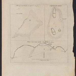
A dangerous shoal seen Septr. the 28, 1767 (Joseph Freewills Islands)

event1773

location_onPhilippines, Indonesia

These three maps are marked with shoals, rocks, water depth, safe entry points, and anchorage locations, to help ships safely anchor. The sites include the Joseph Freewill Islands (Mapia Atoll, Indonesia) and the coast of Mindanao in the Philippines.

Nouvelle Carte de l'isle de Java

eventc.1772-1780

location_onIndonesia

On this map of Java, mountains are shown pictorially and labelled with their name. The coasts are marked with shoals, reefs, bathymetry (sea depth, in figures) and anchor points. The land is divided into administrative districts.

Carte des environs de Batavia = Kaart van de buitenstreeken van Batavia

eventc.1772-1780

location_onIndonesia

This late 18th century map of Batavia (Jakarta) focusses on the network of canals and rivers surrounding the city, as well as the many fields and plantations, including rice fields (‘Champ de Ris’) and sugarcane (‘Cannes de Sucre’).

A chart of the seas between the Straits of Banca and Po. Timon: with the eastern part of the Straits of Malacca

event1767

location_onIndonesia, Malaysia

This mid-18th century maritime map charts the seas between Peninsula Malaysia and Sumatra, including Singapore—named ‘Po. Panjang’—with the old and new Straits of Singapore marked. The numbers indicate sea depth (bathymetry).

Carte du Cours de la Riviere de Tunquin: depuis Cacho jusqu'à La Mer

event1755

location_onVietnam

Map of the Tunquin River (Red or Hong River) from the city of Cacho (Hanoi, Thailand) to its mouth. At the mouth, bathymetry (sea depth), shoals and anchor points are marked. A place named Hean is labelled as an English and French trading post.

close