Search Results

Kaart van het terrein des Oorlogs in Groot-Atjeh in 1876
1883
Indonesia
The Aceh War (1873–1904) between the Sultanate of Aceh and Dutch colonists is highlighted on this map of Groot-Atjeh in 1876. Flag symbols mark the locations of Dutch troops, while a red line records the route marched by ‘agitating troops’ in 1875-6.

Eastern Naga Hills and Manipur with adjoining portions of Burmah
1882
Myanmar
This map shows the border between British India and Burmah (Myanmar). Although the Burmah part of the map is mostly blank, the Chindwin River is shown, along with some other details including a label stating ‘Low hills Covered with dense Forest’.

A Map of South Eastern Asia from Peking to Singapore... with an enlarged plan of the environs of Hanoi, on the Red River
1883
Brunei, Cambodia, Indonesia, Laos, Malaysia, Myanmar, Singapore, Thailand, Vietnam
Map of East Asia, with British colonial possessions—Burma, Straits Settlements, Labuan and British North Borneo—highlighted with red borders. There is also an inset map of the Red River (Hong River) running through Hanoi, Vietnam.

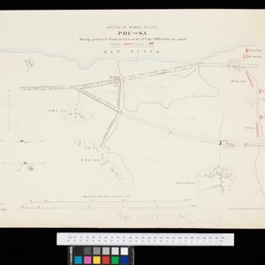
Sketch of works before Phu-sa, showing position of troops at 3 p.m. on the 14th Dec 1883, before the assault
1883
Vietnam
Map of Phu-Sa, a village to the northeast of the city of Sơn Tây (Vietnam), during the Tonkin campaign. It shows French troop positions (on the right, in red) before they attacked the defences of the China-backed Black Flag Army at Phu-Sa

Map of China, Tonquin and Cochin-China, with a chart extending from China to western Europe
1883
Cambodia, Laos, Thailand, Vietnam
Two maps, one of which features mainland Southeast Asia: Anam (Tonquin and Cochin China) in red, Lower Cochin China in green, Cambodia in yellow, and Siam in white. An inset map shows maritime routes between Europe and Asia.


