Search

Search Results

Sketch Map of Mai Cussa or Baxter River, and Wasu Cussa or Chester River, with their tributaries

event1888

location_onPapua New Guinea

Map of an expedition along two rivers on the southern coast of British New Guinea, with notes of terrain (‘Undulating country’), vegetation (‘Coconut Palms’) and wildlife (‘Flying Foxes’). More details have been added by hand (‘Ridge about 10ft.’).

Kaart van Pitoempanoewae en andere landen, toebehoorende aan Boni

event1888

location_onIndonesia

Map of Pitoempanoewae (Pitumpanua) on the east coast of South Sulawesi on the Gulf of Boni. Settlements, rivers, roads and rice fields are marked, with wetlands along the coast and mountains further inland.

Map of the Kingdom of Siam and its dependencies

event1888

location_onCambodia, Laos, Malaysia, Myanmar, Thailand, Vietnam

Map of the Kingdom of Siam, featuring mountains, rivers and villages, and surrounded by a yellow border (the border with Upper Burma and China in the north is undefined). The southern part of Siam is shown on an inset map of the Malay Peninsula.

Plan topographique de l'arrondissement de Tan An

event1888

location_onVietnam

Map of the district of Tan An (Tân An in the Mekong Delta, Vietnam) dominated by the two branches of the Vàm Cỏ River. The city of Tan An is in the centre of the more populated southern part of the district.

Plan topographique de l'arrondissement de Tra Vinh

event1888

location_onVietnam

Map of the province of Tra Vinh (Trà Vinh in the Mekong Delta, Vietnam) situated between the mouths of the Sông Cổ Chiên and Bassac rivers. The city of Tra Vinh is towards the north, surrounded by fields, villages, rivers and roads.

Kaart van zuid Celebes mit uitzondering van het rijk Gowa

event1888

location_onIndonesia

Map of the South Peninsula of Celebes (Sulawesi), spread over four sheets. It features crops (alang-alang, coffee, rice, sugarcane), fishing ponds, salt panning, routes, mountains, forests and settlements. The Gowa Regency is left blank.

Malay, or East Indian Archipelago, with Burmah, Siam &c.

event1887

location_onBrunei, Cambodia, East Timor, Indonesia, Laos, Malaysia, Myanmar, Philippines, Singapore, Southeast Asia, Thailand, Vietnam

On this map of Southeast Asia, numerous small islands, shoals and reefs are marked and named, especially in the South China Sea and around the Sunda and Maluku islands. Submarine cables to carry telegraph messages around the region are also shown.

The town of Singapore

eventc.1887-1888

location_onSingapore

Plan of Singapore town, including Tanjong Pagar docks, the central civic/business area around the Singapore River, and residential areas. The Government House area (now known as The Istana), and areas of Chinese theatres, are highlighted.

Upper Burma: Preliminary map 1887

event1887

location_onMyanmar

Map of Upper Burma, with the city of Mandalay highlighted in red in the centre, and featuring the Irrawaddy and Chindwin rivers, roads and settlements. Mountains, forests and mines (coal, silver, rubies, amber) are marked.

Kaart van de Afdeeling Deli der residentie Oostkust van Sumatra

event1887

location_onIndonesia

A map of the department of Deli, Java, divided into administrative districts, and spread over eight sheets. Rivers, railways, roads and paths, forests and mountains, and crops—rice, coconut, pepper, nutmeg, alang-alang—are marked.

[Map of India]

event1887

location_onMyanmar

This four-sheet map of India—featuring an inset map of Burma (Myanmar) —was created for use in Indian schools by Devendranath Dhar, a self-taught Calcutta-based mapmaker. He sent it to the Royal Asiatic Society for advice on publication.

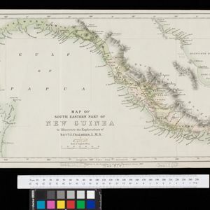
Map of South Eastern part of New Guinea: to illustrate the explorations of Rev. J. Chalmers, L.M.S.

event1887

location_onPapua New Guinea

Map of the southeast coast of British New Guinea, divided into administrative regions, with the northern regions left mostly blank. Based on the explorations of the Scottish missionary James Chalmers.

close

  • Filter from 1630 to 1900

Current results range from 1630 to 1900