Search

Search Results

Topographische kaart der residentie Bagelen

event1860

location_onIndonesia

The residency of Bagelen, Central Java, is shown divided into regencies and districts. Coffee, tea and cinnamon plantations, fields of rice, alang-alang and other crops, mountains, rivers, hot and mineral springs, settlements and routes are marked.

Schets van Malakka en omstreken

eventc.1860

location_onMalaysia

Map of the city of Malakka (Malacca/Melaka) and its surroundings, with rivers, hills and a coastal road marked. There is a military fort, presumably the ‘A Famosa [The Famous]’ fort that is noted on the map as having been demolished.

Zee- en landkaart waarop de dagelijksche vorderingen eener zeereis van Nederland naar N.O. Indië door een deskundig passagier naauwkeurig aangeteekend

eventc.1860

location_onBrunei, Cambodia, East Timor, Indonesia, Laos, Malaysia, Myanmar, Philippines, Singapore, Southeast Asia, Thailand, Vietnam

Map of the Eastern Hemisphere featuring a maritime route from the Netherlands to the port of Batavia (Jakarta) in the East Indies, with each day’s progress marked. Other routes around the region and back to Europe via the Suez Canal are also shown.

Kaart van de residentie Madioen

event1859

location_onIndonesia

A map of the residency of Madioen (Madiun), East Java, divided into regencies and districts. Mountains, rivers and roads are marked, along with postal routes and post offices, sugar factories, cinnamon sheds (‘kaneelloodsen’) and indigo plant mills.

Kaart der telegraaflijnen op Java

event1859

location_onIndonesia

The red lines mark the telegraph lines (‘telegraaflÿnen’) found in mid-19th century Java. The red circles are telegraph offices (‘telegraafkantoren’). Postal routes (‘postwegen’), roads (‘binnenwegen’) and rivers (letter ‘R.’and name) are also shown.

Kaart van assistent-residentie Patjitan

event1859

location_onIndonesia

Map of the residency of Patjitan (Pacitan), south coast of East Java, divided into administrative districts. At the base, there is an elevation (side view) drawing of terrain around the Bay of Patjitan. Villages, forts and ruined temples are marked.

Kaart der residentie Soerakarta

event1859

location_onIndonesia

The residency of Soerakarta in Central Java is shown divided into regencies (yellow borders) and districts (blue borders). There is an inset plan of the capital city, Soerakarta (modern Surakarta), and mountains and land routes are marked.

Kaart van Celebes en Onderhoorigheden

event1858

location_onIndonesia

The 1825 route of the Dutch military officer Major Joseph le Bron de Vexela is marked on this hand-drawn and coloured map of the South Peninsula of Celebes (Sulawesi).

Bijdrage tot eene geologische kaart der residentie Westerafdeeling van Borneo

event1858

location_onIndonesia

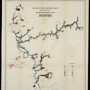
A geological map of western Borneo made by a mine engineer, showing the types of soil, coal, clay, and rock (limestone, sandstone, granite, basalt), as well as gold, diamonds, tin, copper and iron found along the rivers.

Kaart van de westerhelft der residentie Rembang

event1858

location_onIndonesia

Topographic map of the residency of Rembang, Central Java, divided into regencies and districts. Roads and villages are marked, with shoals, reefs and water depth at sea. An inset map of the city of Rembang features markets, warehouses, churches.

close

  • Filter from 1550 to 1900

Current results range from 1550 to 1900