Search

Search Results

Kaart van Nederlandsch Indie

event1895

location_onIndonesia, Singapore, Brunei, Malaysia, East Timor, Philippines

This simple hand-drawn map of maritime Southeast Asia is coloured to highlight the areas under Dutch colonial rule.

Kaart van het Westelijk gedeelte bezet in Groot-Atjèh

event1895

location_onIndonesia

This map of Groot-Atjèh (Aceh, northern Sumatra) focuses on the western part occupied during the Aceh War. It shows mountains, wetlands, forests, villages, routes and crops (rice, coconut, banana, sugar, sugarcane, bamboo, alang-alang, betel).

[Pad van Tangsé naar Kroeng Sabé]

event1895

location_onIndonesia

Map of a path from Tangsé (Tangse) at the top right, southwest to Kroeng Sabi (Krueng Sabee) on the west coast of Aceh, Sumatra. The route crosses mountains and then follows a river to the coast.

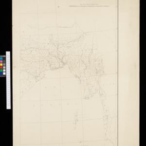
Schetskaart der voormalige Ooster-buitenlinie

event1895

location_onIndonesia

Produced during the Aceh War, the ‘Ooster-buitenlinie [Eastern outer line]’ of this map’s title probably refers to Dutch troop positions—marked with flag symbols—along the red road on the left. The road is east of the city of Kota Radja (Banda Aceh).

Kei- of Ewaf-eilanden

event1895

location_onIndonesia

Map of the Kai Islands, in the Banda Sea, designed for navigation: it features bathymetry (sea depth), tide data (arrows), reefs and shoals. Obstructions in the water are marked ‘kr’ (coral), ‘m’ (mud), ‘s’ (shells), ‘st’ (stones), and ‘z’ (sand).

Wegennet der gemeente Medan

event1895

location_onIndonesia

This map of the town of Medan, north Sumatra, is colour-coded to show land use, reflecting the details of a land lease contract, and including a military camp, Sultan’s palace and land, and residential, agricultural, municipal and government areas.

[Lombok]

event1895

location_onIndonesia

This map of Lombok, in the Lesser Sunda Islands, mainly focuses on roads (marked in red) between the larger settlements. Mountains and rivers are also marked, with shoals, reefs and anchor points around the coast.

Residentie Soerabaja

event1895

location_onIndonesia

There are 64 sheets of this very large-scale (1:20,000) topographic map of the regency of Soerabaja (East Java). Cities and villages, roads, railways and rivers, crops and many more features are all shown in great detail. First sheet is an overview.

Stromkarte von West Borneo... mit Angabe der Stationen und Routen der Niederländischen Expedition in den Jahren 1893 und 1894

event1895

location_onIndonesia

The route of a late 19th century expedition by Dutch geologists, botanists, ethnographers and zoologists is marked on this map of southwest Borneo. Mountain peaks which were surveyed by the geologists are highlighted with a red circle.

Upper Burma

event1895

location_onMyanmar, Thailand

Map of Upper Burma, showing the borders with Assam (India), China and Siam (Thailand), as well as internal administrative borders. Mountains with their heights, settlements, rivers and railways (completed, proposed and under construction) are shown.

India

event1895

location_onMyanmar, Thailand

Although this map focuses on India, it also includes Burma (Myanmar), showing the administrative districts that existed under British colonial rule in the late 19th century. Burma's national borders are orange (with India) and red (with Siam).

India

event1895

location_onMyanmar, Thailand

Although this map focuses on India, it also includes Burma (Myanmar), showing the administrative districts that existed under British colonial rule in the late 19th century.

close