Search

Search Results

Burmah, Siam and Cochin China

event1875

location_onCambodia, Laos, Malaysia, Myanmar, Thailand, Vietnam

This map of mainland Southeast Asia features short texts noting mines, trade routes and travel times (‘5 to 7 days on Elephants’), history (‘conquered by the King of Siam 1809’), peoples (‘states tributary to the Chinese’) and products (‘Tea Tree’).

Birman Empire & countries south east of the Ganges

event1831

location_onCambodia, Indonesia, Laos, Malaysia, Myanmar, Thailand, Vietnam

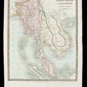
This map of mainland Southeast Asia is divided into colour-coded regions. The Birman Empire (Myanmar) is the most detailed, with internal regions, rivers including the Irrawaddy, mountains and settlements marked.

A New general map of the East Indies, exhibiting in the Peninsula on this side of the Ganges or Hindoostan, the several partitions of the Mogul's Empire

event1823

location_onMalaysia, Brunei, Indonesia, Cambodia, Thailand, Vietnam, Myanmar, Laos, Southeast Asia

This 19th century map highlights British colonial possessions in India (in red), and the various kingdoms of northern Southeast Asia, including the Birman Empire (Myanmar), Cochin China and Tonkin (Vietnam), Lao (Laos), Siam (Thailand), and Cambodia.

close

  • Filter from 1823 to 1875

Current results range from 1823 to 1875