
Search Results


Parts of Burma, Siam and the Shan States
1886
Myanmar, Thailand
This map charts the journey of Holt S. Hallett as he searched for a suitable route for a railway to transport British goods from Burma to Thailand and China. He wrote the book ‘A Thousand Miles on an Elephant in the Shan States’ about his expedition.

Mer des Indes: cartes de la direction et de l'intensité probables des vents
1880
Brunei, Cambodia, Indonesia, Malaysia, Myanmar, Philippines, Thailand, Vietnam, Singapore
A series of four maps of the Indian Ocean—one for each quarter of the calendar year—showing the direction and intensity of the winds, including around the seas of Southeast Asia. There are extensive explanatory notes.

Malay Archipelago, or East India Islands
1851
Brunei, Cambodia, East Timor, Indonesia, Laos, Malaysia, Myanmar, Papua New Guinea, Philippines, Singapore, Southeast Asia, Thailand, Vietnam
This mid-19th century map of Southeast Asia is illustrated with drawings of indigenous people from New Guinea, a ‘bee bear’ (probably a sun bear), a sailboat in front of Victoria Mount in New Guinea, and a village and palm trees in Sarawak, Borneo.

A chart of the Indian and Pacific Oceans with particular plans of the harbours
1847
Brunei, Cambodia, East Timor, Indonesia, Laos, Malaysia, Myanmar, Papua New Guinea, Philippines, Southeast Asia, Singapore, Thailand, Vietnam
Southeast Asia is shown on sheets two and three of this 12-sheet map of the Indian and Pacific oceans, including detailed inset maps of the straits of Singapore, Bangka, Gaspar and Sunda, with bathymetry (sea depth), shoals, reefs, anchorages etc.

Asia cum omnibus Imperiis, Provinciis, Statibus et Insulis correcta et adornata
1840
Brunei, Cambodia, East Timor, Indonesia, Laos, Malaysia, Myanmar, Papua New Guinea, Philippines, Singapore, Southeast Asia, Thailand, Vietnam
This colourful map of Asia has an elaborate cartouche featuring two Asian men talking—one carries a bow, the other smokes a long pipe—while a lion sits nearby. The scale is also illustrated, with drawings of Asian birds.
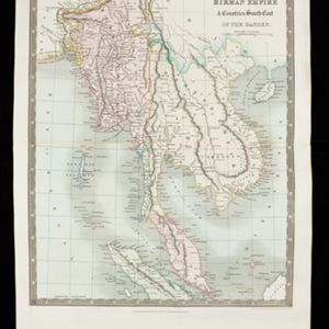
Birman Empire & countries south east of the Ganges
1831
Cambodia, Indonesia, Laos, Malaysia, Myanmar, Thailand, Vietnam
This map of mainland Southeast Asia is divided into colour-coded regions. The Birman Empire (Myanmar) is the most detailed, with internal regions, rivers including the Irrawaddy, mountains and settlements marked.

Birman Empire
1829
Myanmar, Thailand, Laos, Vietnam, Cambodia
This map of the Burman Empire (Myanmar) features mountains, forests and rivers, as well as borders with Siam (Thailand) and Laos. Text notes how far up rivers boats can reach (‘Boats reach hither from the Sea’), ruby mines and rice fields.

Das Kaiserthum Birma nebst Assam
1825
Myanmar, Malaysia, Thailand
Map of the Birman Empire and Assam (modern Myanmar) with detailed text describing the region’s geography, culture, population, religion, government and history. There is an inset map highlighting Burmese islands off the coast of the Malay Peninsula.

Birman Empire
1824
Cambodia, Myanmar, Thailand, Vietnam, Laos
This map of the Burman Empire (Myanmar) features mountains, forests and rivers, as well as borders with Siam (Thailand) and Laos. Text notes how far up rivers boats can reach (‘Boats reach hither from the Sea’), ruby mines and rice fields.
- [remove]Myanmar32
- Thailand30
- Cambodia26
- Malaysia26
- Vietnam26
- Indonesia24
- Laos24
- Brunei23
- Philippines23
- Singapore23
- East Timor22
- Southeast Asia22
- more Simple Location »
- [remove]Martaban32
- Pegu26
- Siam26
- Sumatra24
- Borneo23
- Java23
- Celebes20
- Sulawesi20
- Malay Peninsula19
- Western New Guinea15
- Malacca14
- Cochin China13
- more Detailed Location »


