Search

Search Results

Charte de l'Asie

event1800

location_onBrunei, Cambodia, East Timor, Indonesia, Laos, Malaysia, Myanmar, Papua New Guinea, Philippines, Singapore, Southeast Asia, Thailand, Vietnam

The cartouche on this early 19th century map of Asia features a drawing of an Asian merchant smoking a long pipe while standing with his goods. Behind are a camel and an elephant surrounded by greenery and palm trees.

Asien am Ausgange des XVIIten Jahrhunderts

eventc.1800-1899

location_onBrunei, Cambodia, East Timor, Indonesia, Laos, Malaysia, Myanmar, Philippines, Singapore, Southeast Asia, Thailand, Vietnam

This map of Asia, from an atlas by the German cartographer Karl von Spruner, is colour-coded to show the colonial possessions of the European powers—Netherlands, Portugal, Spain, France, Britain and Denmark—at the end of the 17th century.

Asien gegen Ende des XVIIIten Jahrhunderts

eventc.1800-1899

location_onBrunei, Cambodia, East Timor, Indonesia, Laos, Malaysia, Myanmar, Philippines, Singapore, Southeast Asia, Thailand, Vietnam

This map of Asia, from an atlas by the German cartographer Karl von Spruner, is colour-coded to show the possessions of the Indian Maratha Empire, and of the European colonial powers at the end of the 18th century.

Chart of East Indian Islands exhibiting the several Passages between the Indian and Pacific Oceans

event1800

location_onBrunei, Cambodia, East Timor, Indonesia, Laos, Malaysia, Myanmar, Philippines, Singapore, Southeast Asia, Thailand, Vietnam

Map focusing on the passages between the islands of maritime Southeast Asia. Many 18th century routes are labelled with the ship/captain’s name and date, and there are notes on some shoals and reefs recording names, details and incidents/shipwrecks.

East Indies

eventc.1800-1899

location_onBrunei, Cambodia, East Timor, Indonesia, Laos, Malaysia, Myanmar, Philippines, Singapore, Southeast Asia, Thailand, Vietnam

Longitude is indicated in two different ways on this mid-18th century map: along the top border, it is shown in degrees (number of degrees east of London); more unusually, along the bottom border, it is shown in time (number of hours east of London).

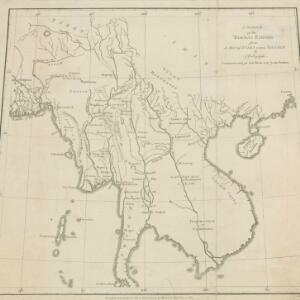
A sketch of the Birman Empire: from a Map of India extra Ganjem

event1800

location_onCambodia, Laos, Myanmar, Thailand, Vietnam

This map from 1800 is by the Scottish cartographer Alexander Dalrymple, who was the first Hydrographer of the British Admiralty. It documents the river systems of the Birman Empire (Myanmar) and modern Thailand, Laos, Cambodia and Vietnam.

Asia, according to the best Authorities

event1795

location_onBrunei, Cambodia, East Timor, Indonesia, Laos, Malaysia, Myanmar, Philippines, Singapore, Southeast Asia, Thailand, Vietnam

A late 18th century map of Asia with regions divided by colour-coded borders, and detailing rivers, mountains, reefs and shoals.

Asia, according to the best Authorities

event1800

location_onBrunei, Cambodia, East Timor, Indonesia, Laos, Malaysia, Myanmar, Philippines, Singapore, Southeast Asia, Thailand, Vietnam

A late 18th century map of Asia with regions divided by colour-coded borders, and detailing rivers, mountains, reefs and shoals.

Bowles's new one-sheet map of Asia, divided into its empires, kingdoms, states, and other subdivisions

event1795

location_onBrunei, Cambodia, East Timor, Indonesia, Laos, Malaysia, Myanmar, Papua New Guinea, Philippines, Singapore, Southeast Asia, Thailand, Vietnam

A late 18th century map of Asia published in London by John Bowles, with regions indicated by colour. Central Borneo is labelled ‘Part inhabited by the Biayos’, which is seen on many contemporary maps, often with the comment ‘a savage people’.

The coast of India from Pulo Timon to Pulo Cambir comprehending the Malayan coast, the Gulf of Siam, the coasts of Tsiampa and Cochinchina, with the adjacent islands and part of the isle of Borneo

event1794

location_onThailand, Malaysia, Cambodia, Indonesia, Brunei, Vietnam

Nautical charts like this are detailed around the coasts and on the seas (e.g. river mouths, islands, shoals and reefs) while the interiors are blank. The web of lines is a rhumbline network, while the numbers indicate sea depth (bathymetry).

Charte von Asien: nach den bewährtesten astronomischen Beobachtungen, den neuesten Reisen, und den vorzüglichsten Charten, insonderheit aber der Geographie des Hrn I.C. Gatterers gemäss

event1793

location_onBrunei, Cambodia, East Timor, Indonesia, Laos, Malaysia, Myanmar, Papua New Guinea, Philippines, Singapore, Southeast Asia, Thailand, Vietnam

Map of Asia, with mainland Southeast Asia in red and divided into ancient kingdoms, Sunda Islands in yellow, and the Philippines in grey. Twelve different scales are shown, as different countries used different measurement systems.

close