Search

Search Results

Eastern Islands: Birmah &c.

event1846

location_onBrunei, Cambodia, East Timor, Indonesia, Laos, Malaysia, Myanmar, Philippines, Singapore, Southeast Asia, Thailand, Vietnam

On this map of Southeast Asia, British colonial territory is highlighted within red borders: the Straits Settlements (Singapore, Malacca and Penang) on the west coast of the Malay Peninsula; and British Burma (Chittagong and Aracan, and Tenasserim).

East India Islands

event1840

location_onVietnam, Myanmar, Papua New Guinea, Philippines, Singapore, Southeast Asia, Thailand, Malaysia, Laos, Indonesia, East Timor, Cambodia, Brunei

The colonial possessions of Britain (in red, though faded on this map), the Netherlands (green, but discoloured to blue) and Spain (the Philippines, brown) are shown on this map, with independent areas such as Borneo and the Maluku Islands in yellow.

Map of Asia: Designed to accompanying Smith's Geography for Schools

event1839

location_onBrunei, Cambodia, Indonesia, Laos, Malaysia, Myanmar, Philippines, Singapore, Thailand, Vietnam, Southeast Asia

Map of Asia, marked with populations of cities and lengths of rivers. Mainland Southeast Asia is divided into kingdoms, but maritime Southeast Asia is mostly blank, and parts such as Java and the Lesser Sunda Islands are left off entirely.

East India Islands

event1839

location_onVietnam, Myanmar, Papua New Guinea, Philippines, Singapore, Southeast Asia, Thailand, Malaysia, Laos, Indonesia, East Timor, Cambodia, Brunei

The shoals and reefs of maritime Southeast Asia are highlighted on this colourful mid-19th century map, with the treacherous waters around many islands and straits marked.

Birman Empire & countries south east of the Ganges

event1834

location_onCambodia, Indonesia, Laos, Malaysia, Myanmar, Singapore, Thailand, Vietnam

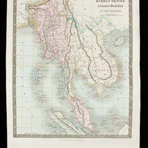
A 19th century map of mainland Southeast Asia, showing the ancient kingdoms of the Birman Empire (roughly modern Myanmar), Malaya (Malaysia), Siam (Thailand), Cochin China and Tonquin (Vietnam), and the Anamese Empire (Cambodia and Laos).

Carte generale de l'Asie: où se trouvent les découvertes faites par Bougainville, Dampier et La Pérouse

event1833

location_onBrunei, Cambodia, East Timor, Indonesia, Laos, Malaysia, Myanmar, Papua New Guinea, Philippines, Singapore, Southeast Asia, Thailand, Vietnam

This map of Asia is marked with the routes taken through Southeast Asia by the British Royal Navy captain James Cook, and the French explorer Lapérouse. The title also refers to two other explorers: Louis Antoine de Bougainville and William Dampier.

Birman Empire & countries south east of the Ganges

event1831

location_onCambodia, Indonesia, Laos, Malaysia, Myanmar, Thailand, Vietnam

This map of mainland Southeast Asia is divided into colour-coded regions. The Birman Empire (Myanmar) is the most detailed, with internal regions, rivers including the Irrawaddy, mountains and settlements marked.

Carte physique et politique de l'Asie

event1822

location_onBrunei, Cambodia, Indonesia, Laos, Malaysia, Myanmar, Papua New Guinea, Philippines, Singapore, Thailand, Vietnam, Southeast Asia

This map of Asia features the ancient kingdoms of mainland Southeast Asia, such as the Birman Empire, Siam, Tonquin and Cochinchina. There are labels noting the inhabitants of some areas, such as 'Biajos' and ‘Tedongs’ in Borneo, and ‘Kemoy’ in Anam.

A Map Illustrative of the Baptist Missionary Stations

event1815

location_onBrunei, Cambodia, East Timor, Indonesia, Laos, Malaysia, Myanmar, Philippines, Singapore, Southeast Asia, Thailand, Vietnam

This map marks the locations of Baptist missionary stations in Asia, including at Ava, Rangoon, Java and Amboyna (Ambon) in Southeast Asia. The station at Java also has a school. The map’s legend lists the stations’ dates of foundation.

close